
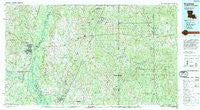
~ Bogalusa LA topo map, 1:100000 scale, 30 X 60 Minute, Historical, 1994, updated 1994
Bogalusa, Louisiana, USGS topographic map dated 1994.
Includes geographic coordinates (latitude and longitude). This topographic map is suitable for hiking, camping, and exploring, or framing it as a wall map.
Printed on-demand using high resolution imagery, on heavy weight and acid free paper, or alternatively on a variety of synthetic materials.
Topos available on paper, Waterproof, Poly, or Tyvek. Usually shipping rolled, unless combined with other folded maps in one order.
- Product Number: USGS-5595076
- Free digital map download (high-resolution, GeoPDF): Bogalusa, Louisiana (file size: 29 MB)
- Map Size: please refer to the dimensions of the GeoPDF map above
- Weight (paper map): ca. 55 grams
- Map Type: POD USGS Topographic Map
- Map Series: HTMC
- Map Verison: Historical
- Cell ID: 67160
- Scan ID: 335162
- Imprint Year: 1994
- Woodland Tint: Yes
- Aerial Photo Year: 1991
- Edit Year: 1994
- Datum: NAD27
- Map Projection: Universal Transverse Mercator
- Map published by United States Geological Survey
- Map Language: English
- Scanner Resolution: 600 dpi
- Map Cell Name: Bogalusa
- Grid size: 30 X 60 Minute
- Date on map: 1994
- Map Scale: 1:100000
- Geographical region: Louisiana, United States
Neighboring Maps:
All neighboring USGS topo maps are available for sale online at a variety of scales.
Spatial coverage:
Topo map Bogalusa, Louisiana, covers the geographical area associated the following places:
- Leetown - Success - Derby - Saucier - Whites Crossing - Carriere - Big Level - Hickory Grove - Bennett (historical) - Walkiah (historical) - Bellamy (historical) - Mabry's Red Barn Trailer Park - Rawhide (historical) - White Sand - Caesar - State Line - Wiggins - Palestine - Fruitland Park - Center (historical) - Mitch (historical) - Centre (historical) - Camp Five (historical) - La Cresta Mobile Home Park - Savannah - Texas - Angie - Perry - Big Hill Mobile Home Park - Liberty Road Mobile Home Park - Riceville - Necaise - Camp Six (historical) - Hovey - Talisheek - Smith Town - Sellers - Riceville (historical) - Stein - Juniper Grove - Henleyfield - Industrial - McHenry - Yamacraw (historical) - Perkinston - Orvisburg - Poplarville - Fords Creek - Crane Creek - Richardson Landing - West Poplarville - Wortham - Picayune - Ozona - Silver Run - Standard - Mill Creek - Hide-A-Way Lake - Hawthorne - Lake View - Bogalusa - Willa - Villa Mobile Home Park - Homestead Mobile Home Park - Young - Plainview - Tyler - Deer Park Phase III Mobile Home Park - Richardson - Howison - Marston (historical) - Varnado - Isabel - Red Top - India - Crossroads - Ten Mile - Bond - Lizana - Airey - Rio - Irvings (historical) - Cybur - Nortac - Bush - Lees Creek - Hillsdale - Beaver Wood Estates - Barth - Rowlands - Carnes - Sun - Millard - McNeill - Chinquapin - Maxie
- Map Area ID: AREA3130.5-90-89
- Northwest corner Lat/Long code: USGSNW31-90
- Northeast corner Lat/Long code: USGSNE31-89
- Southwest corner Lat/Long code: USGSSW30.5-90
- Southeast corner Lat/Long code: USGSSE30.5-89
- Northern map edge Latitude: 31
- Southern map edge Latitude: 30.5
- Western map edge Longitude: -90
- Eastern map edge Longitude: -89


