
~ Baton Rouge LA topo map, 1:100000 scale, 30 X 60 Minute, Historical, 1984, updated 1984
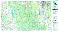
Baton Rouge, Louisiana, USGS topographic map dated 1984.
Includes geographic coordinates (latitude and longitude). This topographic map is suitable for hiking, camping, and exploring, or framing it as a wall map.
Printed on-demand using high resolution imagery, on heavy weight and acid free paper, or alternatively on a variety of synthetic materials.
Topos available on paper, Waterproof, Poly, or Tyvek. Usually shipping rolled, unless combined with other folded maps in one order.
- Product Number: USGS-5595068
- Free digital map download (high-resolution, GeoPDF): Baton Rouge, Louisiana (file size: 28 MB)
- Map Size: please refer to the dimensions of the GeoPDF map above
- Weight (paper map): ca. 55 grams
- Map Type: POD USGS Topographic Map
- Map Series: HTMC
- Map Verison: Historical
- Cell ID: 67105
- Scan ID: 335158
- Imprint Year: 1984
- Woodland Tint: Yes
- Visual Version Number: 1
- Aerial Photo Year: 1982
- Edit Year: 1984
- Datum: NAD27
- Map Projection: Universal Transverse Mercator
- Map published by United States Geological Survey
- Map Language: English
- Scanner Resolution: 600 dpi
- Map Cell Name: Baton Rouge
- Grid size: 30 X 60 Minute
- Date on map: 1984
- Map Scale: 1:100000
- Geographical region: Louisiana, United States
Neighboring Maps:
All neighboring USGS topo maps are available for sale online at a variety of scales.
Spatial coverage:
Topo map Baton Rouge, Louisiana, covers the geographical area associated the following places:
- Donwood - Bruly Saint Martin - Briarcliff - Evangeline Hermitage Estates - Tara - Robin - Tally Ho - Tara Place - Bell Grove Place - Shenandoah Park - Night Recreational Vehicle Park - Siegen - Delmont Place - Anchorage - The Hill - Bayou Paul - Antioch Villa - Ruth - Sable Chase - Dauterive Landing - Belle Rose - Magnolia Woods - Mestayer - Wildwood - Terra Haute - Maringouin - Essen Plaza - Big Oaks Mobile Home Park - Broadmoor - Crescent - Orr (historical) - Staring Acres - Ithra - Ashley - Bruces Mobile Home Park - Sherwood Oaks - Glenmore - Meadow Park - Bruly McCall - Crepe Myrtle Mobile Home Park - South Baton Rouge - Cecilia - McGrath Heights - Plaza 12 Garden Homes - Jones Creek - Lakeside - Beacon Hill - Plantation Mobile Home Park - Saint James - Brightside Park - Goodwood Estates - Grand River - Goodwood - Magnolia - Magnolia Ridge - Oakbrook - Inniswold - Hazel (historical) - Beaulieu - Brusly - Bocage - Midway Mobile Park - Kildare - Magellan Place - Wimbledon Estates - Lukeville - Rhodes - Sunshine - Westdale Terrace - Parks - Quail Run - Chatsworth Acres - Oakwood Forest - Dreyfus (historical) - Millerville - Eliza - Oxford Place - Heatherstone - Silverside - Park Forest East - Leonville - Laurel Ridge - Forest Hill - Foreman - Lynn Place - West Baton Rouge - Shamrock Plaza - Stafford Place - Cinco (historical) - Sumerall - Port Allen - Sarasota Place - Pioneer Park - Chenango - Annadale - Palo Alto - Pecaniere - Ogden Park - Rosedale - Lozes
- Map Area ID: AREA30.530-92-91
- Northwest corner Lat/Long code: USGSNW30.5-92
- Northeast corner Lat/Long code: USGSNE30.5-91
- Southwest corner Lat/Long code: USGSSW30-92
- Southeast corner Lat/Long code: USGSSE30-91
- Northern map edge Latitude: 30.5
- Southern map edge Latitude: 30
- Western map edge Longitude: -92
- Eastern map edge Longitude: -91


