
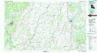
~ Bastrop LA topo map, 1:100000 scale, 30 X 60 Minute, Historical, 1982, updated 1983
Bastrop, Louisiana, USGS topographic map dated 1982.
Includes geographic coordinates (latitude and longitude). This topographic map is suitable for hiking, camping, and exploring, or framing it as a wall map.
Printed on-demand using high resolution imagery, on heavy weight and acid free paper, or alternatively on a variety of synthetic materials.
Topos available on paper, Waterproof, Poly, or Tyvek. Usually shipping rolled, unless combined with other folded maps in one order.
- Product Number: USGS-5595064
- Free digital map download (high-resolution, GeoPDF): Bastrop, Louisiana (file size: 23 MB)
- Map Size: please refer to the dimensions of the GeoPDF map above
- Weight (paper map): ca. 55 grams
- Map Type: POD USGS Topographic Map
- Map Series: HTMC
- Map Verison: Historical
- Cell ID: 76778
- Scan ID: 335156
- Imprint Year: 1983
- Woodland Tint: Yes
- Aerial Photo Year: 1979
- Edit Year: 1982
- Datum: NAD27
- Map Projection: Universal Transverse Mercator
- Map published by United States Geological Survey
- Map Language: English
- Scanner Resolution: 600 dpi
- Map Cell Name: Bastrop
- Grid size: 30 X 60 Minute
- Date on map: 1982
- Map Scale: 1:100000
- Geographical region: Louisiana, United States
Neighboring Maps:
All neighboring USGS topo maps are available for sale online at a variety of scales.
Spatial coverage:
Topo map Bastrop, Louisiana, covers the geographical area associated the following places:
- Warden - Henderson (historical) - Doss (historical) - Twin Bridges - Omega - Hidden Oaks - Hollybrook - Twin Oaks - Arcadia (historical) - Parks Place (historical) - Shelburn - Grimes - Brunett (historical) - Galion - Newhope - Monticello - Newhlock - Tipton (historical) - Ashland - Enoka - Jones - Collinston - Wardville - Floyd - Oak Landing - Bear Skin - Robertdale (historical) - Swartz - Terry - Roosevelt - Kilbourne - Brunswick - Greenfield - Bowie - Stevenson - Chotard - Cleora (historical) - Fiske - County Acres - Arlington - Tallula - Darnell - Lake Providence - Rogers - Forest - Wham - Benham (historical) - Point Pleasant - Oak Grove - Bonita - Mayersville - Vaughn - Haynes Landing - Marcarco - Gum Ridge - Eagle Bend - Green - Bastrop - Cottonwood - New Landgrove Landing - Highland - Causey (historical) - Robinson - Milhaven Estates - Upland - Gassoway - Audubon Park - Hopedale - Bellevule - Hancock - Redwing - Town East - Epps - Lebanon (historical) - Sheltons - Bomer - Quail Creek Estates - Puckettville - Beekman - New Fitler - Mitchiner - Panola - Humphreys - Mer Rouge - Stamboul (historical) - Naff - Windsor - Fitler - Brodnax (historical) - Sondheimer - Alexander (historical) - Transylvania - Alsatia - Jonesburg - Eastwood Estates - Concord - Atherton - Chickasaw - Stampley - Ingomar (historical)
- Map Area ID: AREA3332.5-92-91
- Northwest corner Lat/Long code: USGSNW33-92
- Northeast corner Lat/Long code: USGSNE33-91
- Southwest corner Lat/Long code: USGSSW32.5-92
- Southeast corner Lat/Long code: USGSSE32.5-91
- Northern map edge Latitude: 33
- Southern map edge Latitude: 32.5
- Western map edge Longitude: -92
- Eastern map edge Longitude: -91


