
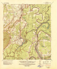
~ Sicily Island LA topo map, 1:62500 scale, 15 X 15 Minute, Historical, 1941, updated 1943
Sicily Island, Louisiana, USGS topographic map dated 1941.
Includes geographic coordinates (latitude and longitude). This topographic map is suitable for hiking, camping, and exploring, or framing it as a wall map.
Printed on-demand using high resolution imagery, on heavy weight and acid free paper, or alternatively on a variety of synthetic materials.
Topos available on paper, Waterproof, Poly, or Tyvek. Usually shipping rolled, unless combined with other folded maps in one order.
- Product Number: USGS-5594778
- Free digital map download (high-resolution, GeoPDF): Sicily Island, Louisiana (file size: 8 MB)
- Map Size: please refer to the dimensions of the GeoPDF map above
- Weight (paper map): ca. 55 grams
- Map Type: POD USGS Topographic Map
- Map Series: HTMC
- Map Verison: Historical
- Cell ID: 62531
- Scan ID: 334990
- Imprint Year: 1943
- Woodland Tint: Yes
- Edit Year: 1941
- Survey Year: 1941
- Datum: NAD
- Map Projection: Polyconic
- Map published by United States Army Corps of Engineers
- Map Language: English
- Scanner Resolution: 600 dpi
- Map Cell Name: Sicily Island
- Grid size: 15 X 15 Minute
- Date on map: 1941
- Map Scale: 1:62500
- Geographical region: Louisiana, United States
Neighboring Maps:
All neighboring USGS topo maps are available for sale online at a variety of scales.
Spatial coverage:
Topo map Sicily Island, Louisiana, covers the geographical area associated the following places:
- Sicily Island - Crescent Landing - Elam - Cut Off Landing - Holly Grove - Olympic Landing - Metropolis - Greenville - OK Landing - Hedgeland Landing - Copeland Landing - Wisner - U and I Landing - Leland - Cooters Landing - Craig Landing - Oakley - Wildwood - Denmark Landing - Norris Springs - Maitland Landing - Young Landing - Mayhew Landing - Foules - Oak Dale Landing - Martins Landing - Anchor Landing - Hunter Landing - Lee Bayou - Kirks Landing - Peck - Alphenia Landing - Maitland - Big A Plenty Landing - Eltringham Landing
- Map Area ID: AREA3231.75-91.75-91.5
- Northwest corner Lat/Long code: USGSNW32-91.75
- Northeast corner Lat/Long code: USGSNE32-91.5
- Southwest corner Lat/Long code: USGSSW31.75-91.75
- Southeast corner Lat/Long code: USGSSE31.75-91.5
- Northern map edge Latitude: 32
- Southern map edge Latitude: 31.75
- Western map edge Longitude: -91.75
- Eastern map edge Longitude: -91.5


