
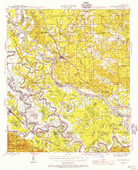
~ Montgomery LA topo map, 1:62500 scale, 15 X 15 Minute, Historical, 1942, updated 1956
Montgomery, Louisiana, USGS topographic map dated 1942.
Includes geographic coordinates (latitude and longitude). This topographic map is suitable for hiking, camping, and exploring, or framing it as a wall map.
Printed on-demand using high resolution imagery, on heavy weight and acid free paper, or alternatively on a variety of synthetic materials.
Topos available on paper, Waterproof, Poly, or Tyvek. Usually shipping rolled, unless combined with other folded maps in one order.
- Product Number: USGS-5594496
- Free digital map download (high-resolution, GeoPDF): Montgomery, Louisiana (file size: 8 MB)
- Map Size: please refer to the dimensions of the GeoPDF map above
- Weight (paper map): ca. 55 grams
- Map Type: POD USGS Topographic Map
- Map Series: HTMC
- Map Verison: Historical
- Cell ID: 57814
- Scan ID: 334819
- Imprint Year: 1956
- Woodland Tint: Yes
- Datum: NAD27
- Map Projection: Polyconic
- Map published by United States Geological Survey
- Map Language: English
- Scanner Resolution: 600 dpi
- Map Cell Name: Montgomery
- Grid size: 15 X 15 Minute
- Date on map: 1942
- Map Scale: 1:62500
- Geographical region: Louisiana, United States
Neighboring Maps:
All neighboring USGS topo maps are available for sale online at a variety of scales.
Spatial coverage:
Topo map Montgomery, Louisiana, covers the geographical area associated the following places:
- Odra - Mars Hill - Cloutierville - Fern - Cockfield (historical) - Mount Zion - Verda - Waddel - Lofton - Henryville (historical) - Old Montgomery (historical) - Hargis - Crews - Emden - Billis (historical) - Wheeling - Montgomery - Boley - Melrose - Aloha - Kadesh - Montrose - Pollockville - Derry - Cognac (historical) - Lakeview - Marco - Magnolia - Wetzlar - New Verda - Williams Corner (historical)
- Map Area ID: AREA31.7531.5-93-92.75
- Northwest corner Lat/Long code: USGSNW31.75-93
- Northeast corner Lat/Long code: USGSNE31.75-92.75
- Southwest corner Lat/Long code: USGSSW31.5-93
- Southeast corner Lat/Long code: USGSSE31.5-92.75
- Northern map edge Latitude: 31.75
- Southern map edge Latitude: 31.5
- Western map edge Longitude: -93
- Eastern map edge Longitude: -92.75


