
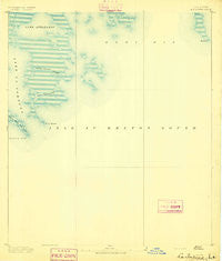
~ La Fortuna LA topo map, 1:62500 scale, 15 X 15 Minute, Historical, 1893
La Fortuna, Louisiana, USGS topographic map dated 1893.
Includes geographic coordinates (latitude and longitude). This topographic map is suitable for hiking, camping, and exploring, or framing it as a wall map.
Printed on-demand using high resolution imagery, on heavy weight and acid free paper, or alternatively on a variety of synthetic materials.
Topos available on paper, Waterproof, Poly, or Tyvek. Usually shipping rolled, unless combined with other folded maps in one order.
- Product Number: USGS-5594286
- Free digital map download (high-resolution, GeoPDF): La Fortuna, Louisiana (file size: 4 MB)
- Map Size: please refer to the dimensions of the GeoPDF map above
- Weight (paper map): ca. 55 grams
- Map Type: POD USGS Topographic Map
- Map Series: HTMC
- Map Verison: Historical
- Cell ID: 56372
- Scan ID: 334703
- Datum: Unstated
- Map Projection: Unstated
- Map published by United States Geological Survey
- Map Language: English
- Scanner Resolution: 600 dpi
- Map Cell Name: La Fortuna
- Grid size: 15 X 15 Minute
- Date on map: 1893
- Map Scale: 1:62500
- Geographical region: Louisiana, United States
Neighboring Maps:
All neighboring USGS topo maps are available for sale online at a variety of scales.
Spatial coverage:
Topo map La Fortuna, Louisiana, covers the geographical area associated the following places:
- Coon Nest Island (historical) - Pass Fernandez - Grace Point (historical) - Raccoon Island (historical) - Mulatto Bayou - Lake Athanasio - Saint Helena Bay - Point Gardner - Mozambique Point Light - Grass Island - Bayou Frenepiquant - Mozambique Point - Deadman Island - Point Chicot Light - Seven Dollar Bay - Chicot Island (historical) - Gardner Island - Breton Sound - Point Eloi - Grassy Island - Point Fortuna (historical) - Frenepiquant Bayou - Canal Pecal - Fiddler Point - Lake Fortuna - Lake Eloi Light 1 - Lake Machias - Deadman Point (historical) - Seven Dollar Bay - Point Chicot (historical)
- Map Area ID: AREA29.7529.5-89.5-89.25
- Northwest corner Lat/Long code: USGSNW29.75-89.5
- Northeast corner Lat/Long code: USGSNE29.75-89.25
- Southwest corner Lat/Long code: USGSSW29.5-89.5
- Southeast corner Lat/Long code: USGSSE29.5-89.25
- Northern map edge Latitude: 29.75
- Southern map edge Latitude: 29.5
- Western map edge Longitude: -89.5
- Eastern map edge Longitude: -89.25


