
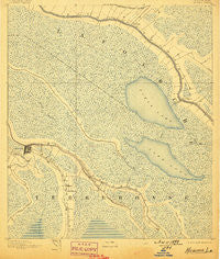
~ Houma LA topo map, 1:62500 scale, 15 X 15 Minute, Historical, 1892, updated 1898
Houma, Louisiana, USGS topographic map dated 1892.
Includes geographic coordinates (latitude and longitude). This topographic map is suitable for hiking, camping, and exploring, or framing it as a wall map.
Printed on-demand using high resolution imagery, on heavy weight and acid free paper, or alternatively on a variety of synthetic materials.
Topos available on paper, Waterproof, Poly, or Tyvek. Usually shipping rolled, unless combined with other folded maps in one order.
- Product Number: USGS-5594206
- Free digital map download (high-resolution, GeoPDF): Houma, Louisiana (file size: 9 MB)
- Map Size: please refer to the dimensions of the GeoPDF map above
- Weight (paper map): ca. 55 grams
- Map Type: POD USGS Topographic Map
- Map Series: HTMC
- Map Verison: Historical
- Cell ID: 55507
- Scan ID: 334659
- Imprint Year: 1898
- Survey Year: 1890
- Datum: Unstated
- Map Projection: Unstated
- Map published by United States Geological Survey
- Map Language: English
- Scanner Resolution: 600 dpi
- Map Cell Name: Houma
- Grid size: 15 X 15 Minute
- Date on map: 1892
- Map Scale: 1:62500
- Geographical region: Louisiana, United States
Neighboring Maps:
All neighboring USGS topo maps are available for sale online at a variety of scales.
Spatial coverage:
Topo map Houma, Louisiana, covers the geographical area associated the following places:
- Sunshine - Millers Mobile Home Park - Mott Trailer Park - Myrtle Grove (historical) - Rita - Mechanicville - Grandbois - Houma - Capri Court Mobile Home Park - Raceland Junction - Utopia (historical) - Carriage Cove Mobile Home Park - Brien's Mobile Village - Argyle - Klondyke - Whispering Oaks Mobile Home and Recreational Vehicle Park - Raceland - Floyd Court Mobile Home Park - Mulberry - Southdown - New Hope (historical) - Godchaux - McLeod - Broadmoor - Ashland - Bowie - Savoie - Bourg - Lockport Heights - Clotilda - Remwood Mobile Home Park - Ravenwood (historical) - Faith Trailer Court - Lockport - Woodlawn - Crozier - Lewistown - Mathews - Presquille
- Map Area ID: AREA29.7529.5-90.75-90.5
- Northwest corner Lat/Long code: USGSNW29.75-90.75
- Northeast corner Lat/Long code: USGSNE29.75-90.5
- Southwest corner Lat/Long code: USGSSW29.5-90.75
- Southeast corner Lat/Long code: USGSSE29.5-90.5
- Northern map edge Latitude: 29.75
- Southern map edge Latitude: 29.5
- Western map edge Longitude: -90.75
- Eastern map edge Longitude: -90.5


