
~ Derouen LA topo map, 1:62500 scale, 15 X 15 Minute, Historical, 1937, updated 1963
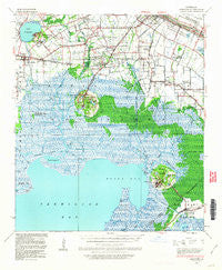
Derouen, Louisiana, USGS topographic map dated 1937.
Includes geographic coordinates (latitude and longitude). This topographic map is suitable for hiking, camping, and exploring, or framing it as a wall map.
Printed on-demand using high resolution imagery, on heavy weight and acid free paper, or alternatively on a variety of synthetic materials.
Topos available on paper, Waterproof, Poly, or Tyvek. Usually shipping rolled, unless combined with other folded maps in one order.
- Product Number: USGS-5593912
- Free digital map download (high-resolution, GeoPDF): Derouen, Louisiana (file size: 9 MB)
- Map Size: please refer to the dimensions of the GeoPDF map above
- Weight (paper map): ca. 55 grams
- Map Type: POD USGS Topographic Map
- Map Series: HTMC
- Map Verison: Historical
- Cell ID: 53371
- Scan ID: 334464
- Imprint Year: 1963
- Woodland Tint: Yes
- Datum: NAD27
- Map Projection: Polyconic
- Map published by United States Geological Survey
- Map published by United States Army Corps of Engineers
- Map published by United States Department of War
- Map Language: English
- Scanner Resolution: 600 dpi
- Map Cell Name: Derouen
- Grid size: 15 X 15 Minute
- Date on map: 1937
- Map Scale: 1:62500
- Geographical region: Louisiana, United States
Neighboring Maps:
All neighboring USGS topo maps are available for sale online at a variety of scales.
Spatial coverage:
Topo map Derouen, Louisiana, covers the geographical area associated the following places:
- Jefferson Island - Iberia Mobile Home Park - Marce - Canebrake Mobile Home Park - Emma - Charlies Mobile Home Village - Brannon - Port of Iberia - Charlotte - Gajan - Santiague - Brousville - Cypremort - Dennison - Lasalle - M and T Mobile Home Park - Weeks - Rynella - Poufette - Lydia - Derouen - Numa - Migues - Duboin - Delcambre - Delaware - Leleux - Olivier - Tree Lawn Trailer Court - Ludger - Little Valley Plantation - Gall - Berard - Davids - Boudreaux - Avery Island - Norbert - Pesson - Alice B - Greig - Nicholas - Bob Acres
- Map Area ID: AREA3029.75-92-91.75
- Northwest corner Lat/Long code: USGSNW30-92
- Northeast corner Lat/Long code: USGSNE30-91.75
- Southwest corner Lat/Long code: USGSSW29.75-92
- Southeast corner Lat/Long code: USGSSE29.75-91.75
- Northern map edge Latitude: 30
- Southern map edge Latitude: 29.75
- Western map edge Longitude: -92
- Eastern map edge Longitude: -91.75


