
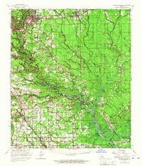
~ Denham Springs LA topo map, 1:62500 scale, 15 X 15 Minute, Historical, 1963, updated 1967
Denham Springs, Louisiana, USGS topographic map dated 1963.
Includes geographic coordinates (latitude and longitude). This topographic map is suitable for hiking, camping, and exploring, or framing it as a wall map.
Printed on-demand using high resolution imagery, on heavy weight and acid free paper, or alternatively on a variety of synthetic materials.
Topos available on paper, Waterproof, Poly, or Tyvek. Usually shipping rolled, unless combined with other folded maps in one order.
- Product Number: USGS-5593908
- Free digital map download (high-resolution, GeoPDF): Denham Springs, Louisiana (file size: 9 MB)
- Map Size: please refer to the dimensions of the GeoPDF map above
- Weight (paper map): ca. 55 grams
- Map Type: POD USGS Topographic Map
- Map Series: HTMC
- Map Verison: Historical
- Cell ID: 53349
- Scan ID: 334462
- Imprint Year: 1967
- Woodland Tint: Yes
- Datum: NAD27
- Map Projection: Polyconic
- Map published by United States Geological Survey
- Map Language: English
- Scanner Resolution: 600 dpi
- Map Cell Name: Denham Springs
- Grid size: 15 X 15 Minute
- Date on map: 1963
- Map Scale: 1:62500
- Geographical region: Louisiana, United States
Neighboring Maps:
All neighboring USGS topo maps are available for sale online at a variety of scales.
Spatial coverage:
Topo map Denham Springs, Louisiana, covers the geographical area associated the following places:
- Lake - Hendricks Mobile Home Park - Hobart - A and W Mobile Home Park - Port Vincent - Pecan Creek - Shenandoah Estates - Pleasant Oaks Mobile Home Park - Eastover Estates Mobile Home Park - Prestige Place Mobile Home Park - Duplessis - Galvez Town - Pate Place - Walker - Coteau Bourgeois - Shenandoah Trails - Bullion - Shady Oaks Mobile Home Park - Eden Church Road Mobile Park - Claybank - Highland Ridge Mobile Home Park - Pecan Cove - Landry's Mobile Home Park - Galvez - Oak Grove - Platation Acres - Raybons Village Mobile Home Park - Little Prairie - S and H Mobile Home Park - Summerfield - Shenandoah Ridge - French Settlement - Ridgecrest Mobile Home Park - The Woods - Comeaux Mobile Park - Hope Villa - Denham Springs - Corbin - Riverview - Big D Mobile Home Park - Brignac - Elliot Acres - Colyell - Cobb's Manufactured Home Park - Seven Oaks Mobile Home Park - Palmetto Mobile Home Park - Deville's Mobile Home Park - Lockhart - Prairieville - Head of Island - Frenchtown Acres - Oak Forest Mobile Home Park - Hopeville (historical) - Twin Lakes Mobile Estates - Poley - Dutch Town - Twin Oaks Mobile Home Park
- Map Area ID: AREA30.530.25-91-90.75
- Northwest corner Lat/Long code: USGSNW30.5-91
- Northeast corner Lat/Long code: USGSNE30.5-90.75
- Southwest corner Lat/Long code: USGSSW30.25-91
- Southeast corner Lat/Long code: USGSSE30.25-90.75
- Northern map edge Latitude: 30.5
- Southern map edge Latitude: 30.25
- Western map edge Longitude: -91
- Eastern map edge Longitude: -90.75


