
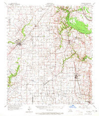
~ Carencro LA topo map, 1:62500 scale, 15 X 15 Minute, Historical, 1957, updated 1965
Carencro, Louisiana, USGS topographic map dated 1957.
Includes geographic coordinates (latitude and longitude). This topographic map is suitable for hiking, camping, and exploring, or framing it as a wall map.
Printed on-demand using high resolution imagery, on heavy weight and acid free paper, or alternatively on a variety of synthetic materials.
Topos available on paper, Waterproof, Poly, or Tyvek. Usually shipping rolled, unless combined with other folded maps in one order.
- Product Number: USGS-5593702
- Free digital map download (high-resolution, GeoPDF): Carencro, Louisiana (file size: 8 MB)
- Map Size: please refer to the dimensions of the GeoPDF map above
- Weight (paper map): ca. 55 grams
- Map Type: POD USGS Topographic Map
- Map Series: HTMC
- Map Verison: Historical
- Cell ID: 52177
- Scan ID: 334351
- Imprint Year: 1965
- Woodland Tint: Yes
- Aerial Photo Year: 1950
- Survey Year: 1957
- Datum: NAD27
- Map Projection: Polyconic
- Map published by United States Geological Survey
- Map published by United States Army Corps of Engineers
- Map Language: English
- Scanner Resolution: 600 dpi
- Map Cell Name: Carencro
- Grid size: 15 X 15 Minute
- Date on map: 1957
- Map Scale: 1:62500
- Geographical region: Louisiana, United States
Neighboring Maps:
All neighboring USGS topo maps are available for sale online at a variety of scales.
Spatial coverage:
Topo map Carencro, Louisiana, covers the geographical area associated the following places:
- Mire - Veltin - Executive Choice Mobile Home Park - Charmon Mobile Home Park - Church Point - Benoit Mobile Park - Prairie Laurent - Ossun - Golden Acres Mobile Home Park - Stekey - Cozy Acres Mobile Home Park - Shiloh Mobile Home Park - Gloria - Lewisburg - Vatican Square Mobile Village - C and D Mobile Home Park - Arceneaux - Cankton - Angelles Mobile Home Community - Higginbotham - Carencro - Hebert Mobile Home Park - Vatican - Grand Coteau - Davids Trailer and Recreational Vehicle Park - Cypress Mobile Estates - Kings Court Mobile Home Park - Parkland Mobile Home Park - Plauches Little Acres Mobile Home Park - Evangeline Trailer Park - Peach Bloom - CBS Mobile Home Park - Conques Mobile Home Park - Indian Hill Mobile Home Park - Cadillac Street Mobile Home Park - Guilbeaux (historical) - Daves Mobile Home Village - La Roulette Mobile Home Park - Melanie Mobile Home Park - Shuteston - Country Pine Mobile Estates - Victoria Village Mobile Home Park - Deshotel - Sunset - Belle Ridge Mobile Home Park - Cajun Mobile Home Village - Mouton - Countryside Mobile Home Park - A and M Mobile Home Park - Castille - Potpourri Village Mobile Home Park - North Acadian Mobile Home Park - Naka - Clifton Camochahe Mobile Home Park - Bristol - Petetin
- Map Area ID: AREA30.530.25-92.25-92
- Northwest corner Lat/Long code: USGSNW30.5-92.25
- Northeast corner Lat/Long code: USGSNE30.5-92
- Southwest corner Lat/Long code: USGSSW30.25-92.25
- Southeast corner Lat/Long code: USGSSE30.25-92
- Northern map edge Latitude: 30.5
- Southern map edge Latitude: 30.25
- Western map edge Longitude: -92.25
- Eastern map edge Longitude: -92


