
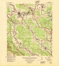
~ Bunkie LA topo map, 1:62500 scale, 15 X 15 Minute, Historical, 1948, updated 1950
Bunkie, Louisiana, USGS topographic map dated 1948.
Includes geographic coordinates (latitude and longitude). This topographic map is suitable for hiking, camping, and exploring, or framing it as a wall map.
Printed on-demand using high resolution imagery, on heavy weight and acid free paper, or alternatively on a variety of synthetic materials.
Topos available on paper, Waterproof, Poly, or Tyvek. Usually shipping rolled, unless combined with other folded maps in one order.
- Product Number: USGS-5593660
- Free digital map download (high-resolution, GeoPDF): Bunkie, Louisiana (file size: 8 MB)
- Map Size: please refer to the dimensions of the GeoPDF map above
- Weight (paper map): ca. 55 grams
- Map Type: POD USGS Topographic Map
- Map Series: HTMC
- Map Verison: Historical
- Cell ID: 51923
- Scan ID: 334325
- Imprint Year: 1950
- Woodland Tint: Yes
- Aerial Photo Year: 1948
- Datum: NAD27
- Map Projection: Polyconic
- Map published by United States Army Corps of Engineers
- Map published by United States Army
- Map Language: English
- Scanner Resolution: 600 dpi
- Map Cell Name: Bunkie
- Grid size: 15 X 15 Minute
- Date on map: 1948
- Map Scale: 1:62500
- Geographical region: Louisiana, United States
Neighboring Maps:
All neighboring USGS topo maps are available for sale online at a variety of scales.
Spatial coverage:
Topo map Bunkie, Louisiana, covers the geographical area associated the following places:
- Karo - Big Cane - Friths (historical) - Dora (historical) - Hickory - McDonald (historical) - Nibot (historical) - Shirley (historical) - Chappel (historical) - Gum Ridge (historical) - Dubuisson - Augusta - Holmesville - Milburn - Saint Louis - Star (historical) - Goudeau - Cottonport - Whiteville - Bubenzer - Rosa - Kelley (historical) - Deats (historical) - Gold Dust - Leinster - Eola - Carboco - Boretta - Degeneres - Le Moyen - Barbreck - Evergreen - Bunkie - Enterprise - Morrow
- Map Area ID: AREA3130.75-92.25-92
- Northwest corner Lat/Long code: USGSNW31-92.25
- Northeast corner Lat/Long code: USGSNE31-92
- Southwest corner Lat/Long code: USGSSW30.75-92.25
- Southeast corner Lat/Long code: USGSSE30.75-92
- Northern map edge Latitude: 31
- Southern map edge Latitude: 30.75
- Western map edge Longitude: -92.25
- Eastern map edge Longitude: -92


