
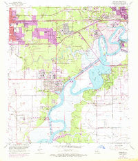
~ Westlake LA topo map, 1:24000 scale, 7.5 X 7.5 Minute, Historical, 1955, updated 1968
Westlake, Louisiana, USGS topographic map dated 1955.
Includes geographic coordinates (latitude and longitude). This topographic map is suitable for hiking, camping, and exploring, or framing it as a wall map.
Printed on-demand using high resolution imagery, on heavy weight and acid free paper, or alternatively on a variety of synthetic materials.
Topos available on paper, Waterproof, Poly, or Tyvek. Usually shipping rolled, unless combined with other folded maps in one order.
- Product Number: USGS-5592372
- Free digital map download (high-resolution, GeoPDF): Westlake, Louisiana (file size: 11 MB)
- Map Size: please refer to the dimensions of the GeoPDF map above
- Weight (paper map): ca. 55 grams
- Map Type: POD USGS Topographic Map
- Map Series: HTMC
- Map Verison: Historical
- Cell ID: 48419
- Scan ID: 333538
- Imprint Year: 1968
- Woodland Tint: Yes
- Photo Revision Year: 1967
- Aerial Photo Year: 1967
- Survey Year: 1955
- Datum: NAD27
- Map Projection: Polyconic
- Map published by United States Geological Survey
- Map Language: English
- Scanner Resolution: 600 dpi
- Map Cell Name: Westlake
- Grid size: 7.5 X 7.5 Minute
- Date on map: 1955
- Map Scale: 1:24000
- Geographical region: Louisiana, United States
Neighboring Maps:
All neighboring USGS topo maps are available for sale online at a variety of scales.
Spatial coverage:
Topo map Westlake, Louisiana, covers the geographical area associated the following places:
- Vincent Landing - Mossville - Meres Mobile Home Park - Mount Dale B Mobile Home Park - Rose Bluff - Westlake - Bayou Country Villa Mobile Home Park - Prien - Southtowner Mobile Estates - Blankenship Mobile Home Park - Hollywood - B B Trailer Park - Acadian Acres Mobile Home Park - Jesse James Mobile Home Park - Smiths Mobile Home Park - Lockmoor - Maplewood
- Map Area ID: AREA30.2530.125-93.375-93.25
- Northwest corner Lat/Long code: USGSNW30.25-93.375
- Northeast corner Lat/Long code: USGSNE30.25-93.25
- Southwest corner Lat/Long code: USGSSW30.125-93.375
- Southeast corner Lat/Long code: USGSSE30.125-93.25
- Northern map edge Latitude: 30.25
- Southern map edge Latitude: 30.125
- Western map edge Longitude: -93.375
- Eastern map edge Longitude: -93.25


