
~ Shreveport West LA topo map, 1:24000 scale, 7.5 X 7.5 Minute, Historical, 1980, updated 1981
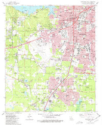
Shreveport West, Louisiana, USGS topographic map dated 1980.
Includes geographic coordinates (latitude and longitude). This topographic map is suitable for hiking, camping, and exploring, or framing it as a wall map.
Printed on-demand using high resolution imagery, on heavy weight and acid free paper, or alternatively on a variety of synthetic materials.
Topos available on paper, Waterproof, Poly, or Tyvek. Usually shipping rolled, unless combined with other folded maps in one order.
- Product Number: USGS-5591828
- Free digital map download (high-resolution, GeoPDF): Shreveport West, Louisiana (file size: 13 MB)
- Map Size: please refer to the dimensions of the GeoPDF map above
- Weight (paper map): ca. 55 grams
- Map Type: POD USGS Topographic Map
- Map Series: HTMC
- Map Verison: Historical
- Cell ID: 41211
- Scan ID: 333249
- Imprint Year: 1981
- Woodland Tint: Yes
- Aerial Photo Year: 1977
- Edit Year: 1980
- Field Check Year: 1977
- Survey Year: 1955
- Datum: NAD27
- Map Projection: Lambert Conformal Conic
- Map published by United States Geological Survey
- Map Language: English
- Scanner Resolution: 600 dpi
- Map Cell Name: Shreveport West
- Grid size: 7.5 X 7.5 Minute
- Date on map: 1980
- Map Scale: 1:24000
- Geographical region: Louisiana, United States
Neighboring Maps:
All neighboring USGS topo maps are available for sale online at a variety of scales.
Spatial coverage:
Topo map Shreveport West, Louisiana, covers the geographical area associated the following places:
- Pine Forest - Hickory Place - Werner Park - Forest Oak - Cross Lake Hills South - Briarcliff - Southdowns - Cynthia Park - Lakewood Village Mobile Home Park - Brown Park Estates - Deep Woods - Rosewood Estates - South Towne Heights - La Rosen - Hollywood - King Forest - Quail Ridge - Pine Forest South - Chasewood - Southport Country - Broadview - Summer Grove - Silver Pine Village - Fairfield - Buncombe (historical) - Hadley - Jewella (historical) - Midway - Colquitt Estates - Fairway Forest - Wildwood South - The Meadows - Cannon - Reisor - Normandy Village - Ridgewood - Pineland Place - Western Hills Village - The Cedars - Longwood Village - La Tierra - Greenbrook - Edgewood Village - Cut-off Junction - Holly Hill - Westwood Park - Forest Villa - Huntington Park - Willow Ridge - Chateau Village - Nichols (historical) - Western Hills Estates - Five Oaks - Elkins - Steeple Chase - Alpha Mobile Home Park - Southern Hills
- Map Area ID: AREA32.532.375-93.875-93.75
- Northwest corner Lat/Long code: USGSNW32.5-93.875
- Northeast corner Lat/Long code: USGSNE32.5-93.75
- Southwest corner Lat/Long code: USGSSW32.375-93.875
- Southeast corner Lat/Long code: USGSSE32.375-93.75
- Northern map edge Latitude: 32.5
- Southern map edge Latitude: 32.375
- Western map edge Longitude: -93.875
- Eastern map edge Longitude: -93.75


