
~ Plaquemine LA topo map, 1:24000 scale, 7.5 X 7.5 Minute, Historical, 1992, updated 1992
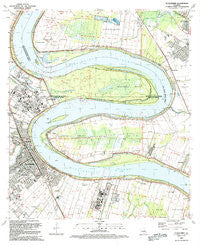
Plaquemine, Louisiana, USGS topographic map dated 1992.
Includes geographic coordinates (latitude and longitude). This topographic map is suitable for hiking, camping, and exploring, or framing it as a wall map.
Printed on-demand using high resolution imagery, on heavy weight and acid free paper, or alternatively on a variety of synthetic materials.
Topos available on paper, Waterproof, Poly, or Tyvek. Usually shipping rolled, unless combined with other folded maps in one order.
- Product Number: USGS-5591486
- Free digital map download (high-resolution, GeoPDF): Plaquemine, Louisiana (file size: 13 MB)
- Map Size: please refer to the dimensions of the GeoPDF map above
- Weight (paper map): ca. 55 grams
- Map Type: POD USGS Topographic Map
- Map Series: HTMC
- Map Verison: Historical
- Cell ID: 35576
- Scan ID: 333066
- Imprint Year: 1992
- Woodland Tint: Yes
- Aerial Photo Year: 1989
- Edit Year: 1992
- Field Check Year: 1991
- Survey Year: 1953
- Datum: NAD27
- Map Projection: Lambert Conformal Conic
- Map published by United States Geological Survey
- Map Language: English
- Scanner Resolution: 600 dpi
- Map Cell Name: Plaquemine
- Grid size: 7.5 X 7.5 Minute
- Date on map: 1992
- Map Scale: 1:24000
- Geographical region: Louisiana, United States
Neighboring Maps:
All neighboring USGS topo maps are available for sale online at a variety of scales.
Spatial coverage:
Topo map Plaquemine, Louisiana, covers the geographical area associated the following places:
- Gardere Place - Highland Creek - Broussard Landing - Sable Chase - Burtville - Evergreen Plantation - Sunshine - Soulouque - Longwood - Morrisonville - Allemania - Seneca Mobile Home Park - Turnerville - Indian Park - University Shadows - Gardere Mobile Park - Plaquemine - Seymourville - Gardere - Riverland - Saint Louis Plantation - Ben Hur (historical) - Evangeline Hermitage Estates - South Highland - Starling (historical) - Saint Louis - Eliza - Myrtle Grove - Sardine Point Settlement (historical) - Riverside Mobile Home Park - Bayou Fountain - Reveille
- Map Area ID: AREA30.37530.25-91.25-91.125
- Northwest corner Lat/Long code: USGSNW30.375-91.25
- Northeast corner Lat/Long code: USGSNE30.375-91.125
- Southwest corner Lat/Long code: USGSSW30.25-91.25
- Southeast corner Lat/Long code: USGSSE30.25-91.125
- Northern map edge Latitude: 30.375
- Southern map edge Latitude: 30.25
- Western map edge Longitude: -91.25
- Eastern map edge Longitude: -91.125


