
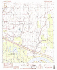
~ Larto Lake North LA topo map, 1:24000 scale, 7.5 X 7.5 Minute, Historical, 1982, updated 1982
Larto Lake North, Louisiana, USGS topographic map dated 1982.
Includes geographic coordinates (latitude and longitude). This topographic map is suitable for hiking, camping, and exploring, or framing it as a wall map.
Printed on-demand using high resolution imagery, on heavy weight and acid free paper, or alternatively on a variety of synthetic materials.
Topos available on paper, Waterproof, Poly, or Tyvek. Usually shipping rolled, unless combined with other folded maps in one order.
- Product Number: USGS-5590504
- Free digital map download (high-resolution, GeoPDF): Larto Lake North, Louisiana (file size: 10 MB)
- Map Size: please refer to the dimensions of the GeoPDF map above
- Weight (paper map): ca. 55 grams
- Map Type: POD USGS Topographic Map
- Map Series: HTMC
- Map Verison: Historical
- Cell ID: 70653
- Scan ID: 332549
- Imprint Year: 1982
- Woodland Tint: Yes
- Visual Version Number: 1
- Aerial Photo Year: 1976
- Edit Year: 1982
- Field Check Year: 1977
- Datum: NAD27
- Map Projection: Lambert Conformal Conic
- Provisional map: Yes
- Map published by United States Geological Survey
- Map Language: English
- Scanner Resolution: 600 dpi
- Map Cell Name: Larto Lake North
- Grid size: 7.5 X 7.5 Minute
- Date on map: 1982
- Map Scale: 1:24000
- Geographical region: Louisiana, United States
Neighboring Maps:
All neighboring USGS topo maps are available for sale online at a variety of scales.
Spatial coverage:
Topo map Larto Lake North, Louisiana, covers the geographical area associated the following places:
- Honey Brake Lake Oil Field - Big Bayou Oil Field - Open Mouth Bayou - Island Bayou - Maknockanut Lake - Lick Branch - Elm Glade - Honey Brake Lake - Gillespie Brake - Hudson Brake - Mount Bayou - Louisiana Delta Plantation Landing Strip - Ward Nine - Foster Ridge - Shad Lake - Burr Lake - Parish Governing Authority District 9 - Big Bayou - Serena Oil Field - Long Branch Oil Field - Babays Lake - Foster Ridge Oil Field - Dry Larto Island - Woods Bayou - Long Branch - Larto Lake - Eagles Nest Brake - Chapman Bay - Big Bayou Cutoff - North Long Branch Oil Field - Larto Lake Oil Field - Cross Bayou Oil Field - Lick Bayou - Honey Brake Bayou - Babays Lake Oil Field - Big Slough - Cypress Bayou
- Map Area ID: AREA31.531.375-92-91.875
- Northwest corner Lat/Long code: USGSNW31.5-92
- Northeast corner Lat/Long code: USGSNE31.5-91.875
- Southwest corner Lat/Long code: USGSSW31.375-92
- Southeast corner Lat/Long code: USGSSE31.375-91.875
- Northern map edge Latitude: 31.5
- Southern map edge Latitude: 31.375
- Western map edge Longitude: -92
- Eastern map edge Longitude: -91.875


