
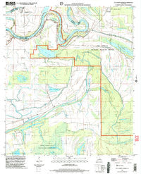
~ Lac Sainte Agnes LA topo map, 1:24000 scale, 7.5 X 7.5 Minute, Historical, 1999, updated 2004
Lac Sainte Agnes, Louisiana, USGS topographic map dated 1999.
Includes geographic coordinates (latitude and longitude). This topographic map is suitable for hiking, camping, and exploring, or framing it as a wall map.
Printed on-demand using high resolution imagery, on heavy weight and acid free paper, or alternatively on a variety of synthetic materials.
Topos available on paper, Waterproof, Poly, or Tyvek. Usually shipping rolled, unless combined with other folded maps in one order.
- Product Number: USGS-5590212
- Free digital map download (high-resolution, GeoPDF): Lac Sainte Agnes, Louisiana (file size: 9 MB)
- Map Size: please refer to the dimensions of the GeoPDF map above
- Weight (paper map): ca. 55 grams
- Map Type: POD USGS Topographic Map
- Map Series: HTMC
- Map Verison: Historical
- Cell ID: 24198
- Scan ID: 332395
- Imprint Year: 2004
- Woodland Tint: Yes
- Datum: NAD83
- Map Projection: Universal Transverse Mercator
- Map published by United States Geological Survey
- Map Language: English
- Scanner Resolution: 600 dpi
- Map Cell Name: Lac Sainte Agnes
- Grid size: 7.5 X 7.5 Minute
- Date on map: 1999
- Map Scale: 1:24000
- Geographical region: Louisiana, United States
Neighboring Maps:
All neighboring USGS topo maps are available for sale online at a variety of scales.
Spatial coverage:
Topo map Lac Sainte Agnes, Louisiana, covers the geographical area associated the following places:
- Bayou de la Glaise - Petit Lac du Grand Bryon - Cyprière à Oncle John - Lac Ophelia - Bayou Chambré - Lac en Travers - Lac Barbue - Bayou La Taure - Lac Bryon de Chats - Lac Saulière - Short Fork - Big Canal - Pointe Tournant - Twisty Bayou - Lake Frazier Swamp - Lake Ophelia Oil Field - Indian Cypress Brake - Lac Ambroise - Long Fork - Lac Clair - Lac Sainte Agnes - Bayou Voiche - Saint James Chapel - La Saulière - Little River Oil Field - Baie Sec - La Coulee à Elphege - Lac Grand Bayou - Lac a Paul - Old Red River - Lac Valerie - Lake Ophelia National Wildlife Refuge - Bayou La Croix - Westcut Lake - Lake Little Solier - Grand Cyprière - Lac Moreau - Petit Lac Saulière - Mouillere a Dehors - Bayou Voinche - Louisiana Delta South End Landing Strip - La Paries Church - Bill Book Lake - Parish Governing Authority District 3 - Bayou Cocodrie
- Map Area ID: AREA31.2531.125-92-91.875
- Northwest corner Lat/Long code: USGSNW31.25-92
- Northeast corner Lat/Long code: USGSNE31.25-91.875
- Southwest corner Lat/Long code: USGSSW31.125-92
- Southeast corner Lat/Long code: USGSSE31.125-91.875
- Northern map edge Latitude: 31.25
- Southern map edge Latitude: 31.125
- Western map edge Longitude: -92
- Eastern map edge Longitude: -91.875


