
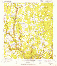
~ Comite LA topo map, 1:24000 scale, 7.5 X 7.5 Minute, Historical, 1953, updated 1954
Comite, Louisiana, USGS topographic map dated 1953.
Includes geographic coordinates (latitude and longitude). This topographic map is suitable for hiking, camping, and exploring, or framing it as a wall map.
Printed on-demand using high resolution imagery, on heavy weight and acid free paper, or alternatively on a variety of synthetic materials.
Topos available on paper, Waterproof, Poly, or Tyvek. Usually shipping rolled, unless combined with other folded maps in one order.
- Product Number: USGS-5588928
- Free digital map download (high-resolution, GeoPDF): Comite, Louisiana (file size: 9 MB)
- Map Size: please refer to the dimensions of the GeoPDF map above
- Weight (paper map): ca. 55 grams
- Map Type: POD USGS Topographic Map
- Map Series: HTMC
- Map Verison: Historical
- Cell ID: 9761
- Scan ID: 331727
- Imprint Year: 1954
- Woodland Tint: Yes
- Aerial Photo Year: 1952
- Survey Year: 1953
- Datum: NAD27
- Map Projection: Polyconic
- Map published by United States Geological Survey
- Map Language: English
- Scanner Resolution: 600 dpi
- Map Cell Name: Comite
- Grid size: 7.5 X 7.5 Minute
- Date on map: 1953
- Map Scale: 1:24000
- Geographical region: Louisiana, United States
Neighboring Maps:
All neighboring USGS topo maps are available for sale online at a variety of scales.
Spatial coverage:
Topo map Comite, Louisiana, covers the geographical area associated the following places:
- Joor Road Mobile Home Park - Willow Creek - Crystal Place - Greenwood Estates - Tanglewood - Boganvilla - Central Estates - Country Estate Acres - Hidden Creek - Waters Edge - Northeast Place - Twin Oaks - Pecan Ridge - Green Acres - Cedar Mill Run - Beabois Place - South Merrydale - Cimmaron - Puckett - Yorkdale - Whispering Oaks - Comite Hills West - Pleasant Hills - Central - Greendale - Bridlewood - Ski Stone - Welcome Heights - Glen Oaks Place - White Oak Run - Woodland View - Winchester - Tanglewood West Trailer Park - Alford Acres - Phebus - Bon Dickey - Glenbrook - Brown Heights - East Ridgewood - Sherrington Place - Comite Estates - Morgan Place West - East Fairlane - Forest Glen Estates - Comite - Pinewood Acres - El Ranchito - Plantation Way - East Glen - Morgan Place - Greenwood - Brian Estates - Green Gate - Oak Cluster - Woods Edge - Huntington Park - Four Season Mobile Home Park - Greenwell Acres East - Rambling Oaks - Ridgewood - Jackson Park - Myrick Place - Comite Hills - Carmel Acres - Forest Park - Jackson Place - Brownsfield - Merrydale - Oak Shadows Place - Holiday Woods - Klienpeter Terrace - Monhegan - Forest Heights Park - Willowood Acres - Crystal Place Mobile Home Park - Lazy Lake Estates - Mickens Place - Central Place - Biltmore - Centerra - Huntley Place - Brandon Place
- Map Area ID: AREA30.62530.5-91.125-91
- Northwest corner Lat/Long code: USGSNW30.625-91.125
- Northeast corner Lat/Long code: USGSNE30.625-91
- Southwest corner Lat/Long code: USGSSW30.5-91.125
- Southeast corner Lat/Long code: USGSSE30.5-91
- Northern map edge Latitude: 30.625
- Southern map edge Latitude: 30.5
- Western map edge Longitude: -91.125
- Eastern map edge Longitude: -91


