
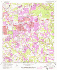
~ Baton Rouge East LA topo map, 1:24000 scale, 7.5 X 7.5 Minute, Historical, 1963, updated 1981
Baton Rouge East, Louisiana, USGS topographic map dated 1963.
Includes geographic coordinates (latitude and longitude). This topographic map is suitable for hiking, camping, and exploring, or framing it as a wall map.
Printed on-demand using high resolution imagery, on heavy weight and acid free paper, or alternatively on a variety of synthetic materials.
Topos available on paper, Waterproof, Poly, or Tyvek. Usually shipping rolled, unless combined with other folded maps in one order.
- Product Number: USGS-5588162
- Free digital map download (high-resolution, GeoPDF): Baton Rouge East, Louisiana (file size: 14 MB)
- Map Size: please refer to the dimensions of the GeoPDF map above
- Weight (paper map): ca. 55 grams
- Map Type: POD USGS Topographic Map
- Map Series: HTMC
- Map Verison: Historical
- Cell ID: 2642
- Scan ID: 331320
- Imprint Year: 1981
- Woodland Tint: Yes
- Photo Revision Year: 1980
- Aerial Photo Year: 1979
- Edit Year: 1980
- Survey Year: 1963
- Datum: NAD27
- Map Projection: Polyconic
- Map published by United States Geological Survey
- Map Language: English
- Scanner Resolution: 600 dpi
- Map Cell Name: Baton Rouge East
- Grid size: 7.5 X 7.5 Minute
- Date on map: 1963
- Map Scale: 1:24000
- Geographical region: Louisiana, United States
Neighboring Maps:
All neighboring USGS topo maps are available for sale online at a variety of scales.
Spatial coverage:
Topo map Baton Rouge East, Louisiana, covers the geographical area associated the following places:
- Burden Estates - Shiloh - Park Forest - Sherwood Garden Homes - Goodwood Homesites - Mayfair Park North - Woodland Ridge Park - Palm Hills - West River Oaks - Acadian Place - Antioch Villa - Essen - Magnolia Woods - Silverside Heights Garden - Kildare - Plaza 12 Garden Homes - Oxford Place - Hillside - Brandon Hollow - Oak Park - Rushmore - Pasadena - Wimbledon Estates - Madeline Court - Forest Oaks - East Broadmoor - Ashley - Broadmoor Place - Beacon Hill - Woodlawn Estates - Silverside - Jefferson Terrace - Riffel Place - Oak Forest - Southmoore - Normandy Acres - Inniswold - Stevendale Estates - Broadmoor Estates - Independence Place - Southpark - Keaty Place - Shenandoah Square - Courtland Place - Parkland Terrace - Tara - Del Rey Plaza - Sharp - Goodwood - Villa Del Rey - Bristol - Shenandoah North - Green Back Forest - Sherwood Oaks South - Li Rocchi - Fox Run - Country Club Estates - Royal Oak - Howell Park - Stevendale Heights - Afton Oaks - Big Oaks Mobile Home Park - Inniswold Estates - Greenwell Forest - Executive Park - Parkview Oaks South - Quail Run - Eastgate - Broadmoor Mobile Home Park - Jefferson Terrace East - Broadmoor Forest - Pioneer Park - Essen South - Airline Acres - Red Oak - Stevensdale - Wooddale East - Hillcrest Acres - Monticello - Walden - Partridge Lane Heights - Sherwood Forest - Shadowbrook - Randolph Heights - Melrose East - Woodland Ridge - Woodshire Village - Wellington - Sherwood Forest Estates - The Hideaway - Village Cote - Perkins Place - North Red Oaks - Carmen Terrace - Bell Grove Place - O'Neal Place - Aubin - Oakwood Forest - Lake Forest Park - Parkview Oaks
- Map Area ID: AREA30.530.375-91.125-91
- Northwest corner Lat/Long code: USGSNW30.5-91.125
- Northeast corner Lat/Long code: USGSNE30.5-91
- Southwest corner Lat/Long code: USGSSW30.375-91.125
- Southeast corner Lat/Long code: USGSSE30.375-91
- Northern map edge Latitude: 30.5
- Southern map edge Latitude: 30.375
- Western map edge Longitude: -91.125
- Eastern map edge Longitude: -91


