
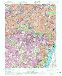
~ Webster Groves MO topo map, 1:24000 scale, 7.5 X 7.5 Minute, Historical, 1954, updated 1983
Webster Groves, Missouri, USGS topographic map dated 1954.
Includes geographic coordinates (latitude and longitude). This topographic map is suitable for hiking, camping, and exploring, or framing it as a wall map.
Printed on-demand using high resolution imagery, on heavy weight and acid free paper, or alternatively on a variety of synthetic materials.
Topos available on paper, Waterproof, Poly, or Tyvek. Usually shipping rolled, unless combined with other folded maps in one order.
- Product Number: USGS-5581106
- Free digital map download (high-resolution, GeoPDF): Webster Groves, Missouri (file size: 23 MB)
- Map Size: please refer to the dimensions of the GeoPDF map above
- Weight (paper map): ca. 55 grams
- Map Type: POD USGS Topographic Map
- Map Series: HTMC
- Map Verison: Historical
- Cell ID: 47921
- Scan ID: 324469
- Imprint Year: 1983
- Woodland Tint: Yes
- Photo Inspection Year: 1979
- Photo Revision Year: 1974
- Aerial Photo Year: 1974
- Field Check Year: 1954
- Survey Year: 1933
- Datum: NAD27
- Map Projection: Polyconic
- Map published by United States Geological Survey
- Map Language: English
- Scanner Resolution: 600 dpi
- Map Cell Name: Webster Groves
- Grid size: 7.5 X 7.5 Minute
- Date on map: 1954
- Map Scale: 1:24000
- Geographical region: Missouri, United States
Neighboring Maps:
All neighboring USGS topo maps are available for sale online at a variety of scales.
Spatial coverage:
Topo map Webster Groves, Missouri, covers the geographical area associated the following places:
- Webster Groves - Shrewsbury - Grantwood Village - Brentwood - Lake Junction - Mackenzie - Bella Villa - Marlborough - Gratiot - Ellendale - Tower Grove - Green Park - Maplewood - Southhampton - Saint George - Broadway - Clifton Heights - Lakeshire - Carondelet - Ivory - Wilbur Park - The Hill - Grantwood - Affton - Concord - Mehlville - Benton - Lemay - Jefferson Barracks - Hathaway Meadows
- Map Area ID: AREA38.62538.5-90.375-90.25
- Northwest corner Lat/Long code: USGSNW38.625-90.375
- Northeast corner Lat/Long code: USGSNE38.625-90.25
- Southwest corner Lat/Long code: USGSSW38.5-90.375
- Southeast corner Lat/Long code: USGSSE38.5-90.25
- Northern map edge Latitude: 38.625
- Southern map edge Latitude: 38.5
- Western map edge Longitude: -90.375
- Eastern map edge Longitude: -90.25


