
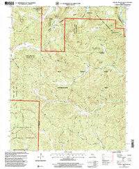
~ Stegall Mountain MO topo map, 1:24000 scale, 7.5 X 7.5 Minute, Historical, 1997, updated 2000
Stegall Mountain, Missouri, USGS topographic map dated 1997.
Includes geographic coordinates (latitude and longitude). This topographic map is suitable for hiking, camping, and exploring, or framing it as a wall map.
Printed on-demand using high resolution imagery, on heavy weight and acid free paper, or alternatively on a variety of synthetic materials.
Topos available on paper, Waterproof, Poly, or Tyvek. Usually shipping rolled, unless combined with other folded maps in one order.
- Product Number: USGS-5580650
- Free digital map download (high-resolution, GeoPDF): Stegall Mountain, Missouri (file size: 16 MB)
- Map Size: please refer to the dimensions of the GeoPDF map above
- Weight (paper map): ca. 55 grams
- Map Type: POD USGS Topographic Map
- Map Series: HTMC
- Map Verison: Historical
- Cell ID: 43070
- Scan ID: 324229
- Imprint Year: 2000
- Woodland Tint: Yes
- Aerial Photo Year: 1995
- Datum: NAD27
- Map Projection: Transverse Mercator
- Map published by United States Geological Survey
- Map published by United States Forest Service
- Map Language: English
- Scanner Resolution: 600 dpi
- Map Cell Name: Stegall Mountain
- Grid size: 7.5 X 7.5 Minute
- Date on map: 1997
- Map Scale: 1:24000
- Geographical region: Missouri, United States
Neighboring Maps:
All neighboring USGS topo maps are available for sale online at a variety of scales.
Spatial coverage:
Topo map Stegall Mountain, Missouri, covers the geographical area associated the following places:
- Greene Hollow - Big Caney Hollow - Greeley Hollow - Stalcup Hollow - Denning Hollow - Spur Hollow - Little Thorny Mountain - Mill Mountain - Prairie Hollow - White Oak Hollow - Horner School (historical) - Log Spring Hollow - Silo Hollow - Mule Mountain - Reed Cemetery - Roebell Mountain - Callahan Hollow - Horner Hollow - Slick Rock Hollow - Mud Spring Hollow - Horner Church - Winding Stairs Hollow - Lane Hollow - Little Rocky Creek - Kelley Hollow - Stalcup Hollow - Mill Creek School (historical) - Mule Hollow - Brandewiede Hollow - Strong Hollow - Mule Hollow - Peck Ranch State Wildlife Management Area - Buzzard Mountain - Shut-In Mountain - Rocky Falls - Black Oak Hollow - Little Caney Hollow - Long Hollow - Wildcat Hollow - Cardareva School - Cane Hollow - Rocky Falls Picnic Area - Cardareva Ford (historical) - Hay Hollow - Liberty School (historical) - Terrapin Hollow - Pritchard Hollow - Stegall Mountain - Mule Mountain State Forest - Reed School (historical) - Thorny Mountain
- Map Area ID: AREA37.12537-91.25-91.125
- Northwest corner Lat/Long code: USGSNW37.125-91.25
- Northeast corner Lat/Long code: USGSNE37.125-91.125
- Southwest corner Lat/Long code: USGSSW37-91.25
- Southeast corner Lat/Long code: USGSSE37-91.125
- Northern map edge Latitude: 37.125
- Southern map edge Latitude: 37
- Western map edge Longitude: -91.25
- Eastern map edge Longitude: -91.125


