
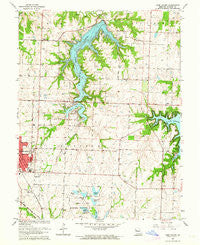
~ Lake Jacomo MO topo map, 1:24000 scale, 7.5 X 7.5 Minute, Historical, 1963, updated 1964
Lake Jacomo, Missouri, USGS topographic map dated 1963.
Includes geographic coordinates (latitude and longitude). This topographic map is suitable for hiking, camping, and exploring, or framing it as a wall map.
Printed on-demand using high resolution imagery, on heavy weight and acid free paper, or alternatively on a variety of synthetic materials.
Topos available on paper, Waterproof, Poly, or Tyvek. Usually shipping rolled, unless combined with other folded maps in one order.
- Product Number: USGS-5578678
- Free digital map download (high-resolution, GeoPDF): Lake Jacomo, Missouri (file size: 13 MB)
- Map Size: please refer to the dimensions of the GeoPDF map above
- Weight (paper map): ca. 55 grams
- Map Type: POD USGS Topographic Map
- Map Series: HTMC
- Map Verison: Historical
- Cell ID: 24486
- Scan ID: 323201
- Imprint Year: 1964
- Woodland Tint: Yes
- Aerial Photo Year: 1955
- Survey Year: 1934
- Datum: NAD27
- Map Projection: Polyconic
- Map published by United States Geological Survey
- Map Language: English
- Scanner Resolution: 600 dpi
- Map Cell Name: Lake Jacomo
- Grid size: 7.5 X 7.5 Minute
- Date on map: 1963
- Map Scale: 1:24000
- Geographical region: Missouri, United States
Neighboring Maps:
All neighboring USGS topo maps are available for sale online at a variety of scales.
Spatial coverage:
Topo map Lake Jacomo, Missouri, covers the geographical area associated the following places:
- Lee's Summit High School - Lone Summit Lake Dam - Sailboat Cove Launching and Mooring - Prairie Lee Lake Dam - Catclaw Lake Dam - Big Rock Bay - Lakewood Lake East - Moreland Ridge Middle School - Fleming Park - Prairie Lee Lake - City of Lake Lotawana - North Prairie Lee Park - Lake Nell Dam - Tennison School (historical) - Bayberry Plaza Shopping Center - Franke Soccer Fields - Cyclone School (historical) - Delta School (historical) - Cowherd Cemetery - Great Beginnings Early Education Center - Fleming Meeting Hall - Langsford House School - Native Hoofed Animal Enclosure - Delta Woods Middle School - Liggett Trail Education Center - Jackson County Sheriff's Office - Lake Jacomo - Ligget Cove - Lone Oak School (historical) - Lees Summit Fire Department Station 4 - Missouri State Highway Patrol Troop A - South Prairie Lee Park - Woodland Elementary School - Baird School (historical) - Chapel Lakes Elementary School - Sailboat Cove - Meadow Lane Elementary School - Highland Park Elementary School - Cottontail Lake Dam - Prairie View Elementary School - Gopher Lake - Prairie Township Fire Protection District - Buffalo Cove - Lees Summit Town Center Shopping Center - Central Jackson County Fire Protection District Station 5 - Interchange 12 - Lake Lotawana - Prairie Lee Church - Lees Summit Fire Department Station 2 - Cottontail Lake - Lakewood Lakes - Richardson Elementary School - Sunset Bay - Jackson County Park Headquarters - Jackrabbit Lake Dam - Woods Chapel - Fleming East Nature Preserve - Township of Prairie - Plover Lake Dam - Plover Lake - Jackrabbit Lake - Christiansen Lake - Christiansen Lake Dam - Lee's Summit R B Rice Post Office - Chapel Woods Golf Course Lake Dam - Bernard C Campbell Middle School - Saint Marys School - James A Reed Memorial Wildlife Area - Underwood Elementary School - Valle Vista Shopping Center - Lake Jacomo Dam - Summit Springs Shopping Center - Interchange 10A and 10B - Radio Control Flying Field - Community Church - Missouri Department of Conservation Shelter - Miller Park Center - Lee's Summit Medical Center - Number 38 Lake - Missouri Town - Lotawana Fire Protection District Station 1 - Barber Lake Dam - Cordill - Mason Elementary School - Catclaw Lake - Colburn School (historical) - Lotawana Fire Protection District Station 2 - Mason Elementary School - Kemper Outdoor Education Center - Center Point School (historical) - Lake Nell - Rotary Camp - Wright School (historical) - Stafford Airport (historical) - Jacomo Marina - Daniel Young Elementary School - Audubon Library - Lee's Summit Cemetery - Lake Lotawana Police Department - Lees Summit Fire Department Station 6 - Sunset Valley Elementary School
- Map Area ID: AREA3938.875-94.375-94.25
- Northwest corner Lat/Long code: USGSNW39-94.375
- Northeast corner Lat/Long code: USGSNE39-94.25
- Southwest corner Lat/Long code: USGSSW38.875-94.375
- Southeast corner Lat/Long code: USGSSE38.875-94.25
- Northern map edge Latitude: 39
- Southern map edge Latitude: 38.875
- Western map edge Longitude: -94.375
- Eastern map edge Longitude: -94.25


