
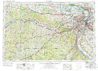
~ St Louis MO topo map, 1:250000 scale, 1 X 2 Degree, Historical, 1963, updated 1974
St Louis, Missouri, USGS topographic map dated 1963.
Includes geographic coordinates (latitude and longitude). This topographic map is suitable for hiking, camping, and exploring, or framing it as a wall map.
Printed on-demand using high resolution imagery, on heavy weight and acid free paper, or alternatively on a variety of synthetic materials.
Topos available on paper, Waterproof, Poly, or Tyvek. Usually shipping rolled, unless combined with other folded maps in one order.
- Product Number: USGS-5575948
- Free digital map download (high-resolution, GeoPDF): St Louis, Missouri (file size: 25 MB)
- Map Size: please refer to the dimensions of the GeoPDF map above
- Weight (paper map): ca. 55 grams
- Map Type: POD USGS Topographic Map
- Map Series: HTMC
- Map Verison: Historical
- Cell ID: 69004
- Scan ID: 325631
- Imprint Year: 1974
- Woodland Tint: Yes
- Visual Version Number: 1
- Aerial Photo Year: 1961
- Edit Year: 1969
- Field Check Year: 1963
- Datum: Unstated
- Map Projection: Transverse Mercator
- Map published by United States Geological Survey
- Map published by: Military, Other
- Map Language: English
- Scanner Resolution: 600 dpi
- Map Cell Name: Saint Louis
- Grid size: 1 X 2 Degree
- Date on map: 1963
- Map Scale: 1:250000
- Geographical region: Missouri, United States
Neighboring Maps:
All neighboring USGS topo maps are available for sale online at a variety of scales.
Spatial coverage:
Topo map St Louis, Missouri, covers the geographical area associated the following places:
- Baltimore Settlement - Cheltenham - Greendale - Gildehouse - Matson - Ogles - Fernridge - Crestwood - Kohl City - Ascalon - Jefferson Heights - Berdell Hills - Hulsey - Plum Ford - Pasadena Park - Hayden - Benbush - Lonedell - Moro - Ivory - Ellendale - Southmoor - Pine Lawn - Regina - Rabbitville - Harrisonville - Berkeley - Bellerive Acres - Marigold - Notre Dame - Larimore - Lakeshire - College Hill - Bridgeton Terrace - Portage Des Sioux - Little Rock Landing - Pitcher - Fountain Park - Tebbetts - Imbs - Skinker - Seeburger - Lois - Godfrey - Rockford Beach - Peers - Hanley Hills - Richmond Heights - Pendleton - Hilltop - Laubinger Ford - Drake - Lyon - Koch (historical) - Valley View - Brown Shanty - Edmundson - Maplewood Park - Golden Eagle - Beck - Lake Siding - Bloomsdale - Sullivan - Burksville Station - Mitchell - Granite City - Hofflins - Glendale - Golden Gardens - State Park Place - Petersville - Lincoln Beach - Villa Ridge - High Hill - Valley Park - Heilburn (historical) - Toonerville - Mehlville - Foster Pond (historical) - Clarkson Valley - Northwoods - Strain - Floraville - Bunkum - Mattese - Oakvale - Champion City - Maupin - Velda Village Hills - Starkenburg - Grover - Olivette - Orchard Farm - Marlborough - Beverly Hills - Crest Hill - Cedar Bluff - Merrimac - Koester - Ludwig
- Map Area ID: AREA3938-92-90
- Northwest corner Lat/Long code: USGSNW39-92
- Northeast corner Lat/Long code: USGSNE39-90
- Southwest corner Lat/Long code: USGSSW38-92
- Southeast corner Lat/Long code: USGSSE38-90
- Northern map edge Latitude: 39
- Southern map edge Latitude: 38
- Western map edge Longitude: -92
- Eastern map edge Longitude: -90


