
~ St Louis MO topo map, 1:250000 scale, 1 X 2 Degree, Historical, 1963, updated 1974
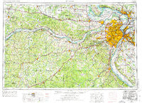
St Louis, Missouri, USGS topographic map dated 1963.
Includes geographic coordinates (latitude and longitude). This topographic map is suitable for hiking, camping, and exploring, or framing it as a wall map.
Printed on-demand using high resolution imagery, on heavy weight and acid free paper, or alternatively on a variety of synthetic materials.
Topos available on paper, Waterproof, Poly, or Tyvek. Usually shipping rolled, unless combined with other folded maps in one order.
- Product Number: USGS-5575944
- Free digital map download (high-resolution, GeoPDF): St Louis, Missouri (file size: 24 MB)
- Map Size: please refer to the dimensions of the GeoPDF map above
- Weight (paper map): ca. 55 grams
- Map Type: POD USGS Topographic Map
- Map Series: HTMC
- Map Verison: Historical
- Cell ID: 69004
- Scan ID: 325629
- Imprint Year: 1974
- Woodland Tint: Yes
- Aerial Photo Year: 1961
- Edit Year: 1969
- Field Check Year: 1963
- Datum: Unstated
- Map Projection: Transverse Mercator
- Map published by United States Geological Survey
- Map published by: Military, Other
- Map Language: English
- Scanner Resolution: 600 dpi
- Map Cell Name: Saint Louis
- Grid size: 1 X 2 Degree
- Date on map: 1963
- Map Scale: 1:250000
- Geographical region: Missouri, United States
Neighboring Maps:
All neighboring USGS topo maps are available for sale online at a variety of scales.
Spatial coverage:
Topo map St Louis, Missouri, covers the geographical area associated the following places:
- Pohlman Mill - Hensley - Yeatman - Bourbon - Wydown Skinker - Covenant Blu-Grand Center - Meramec Terrace - Jeffriesburg - Echo Lake Ranch - Vilander - Darmstadt (historical) - Mokane - McKittrick - North Pointe - Tyson - La Salle - Overland - West Sullivan - Bluffside - Hanley Hills - Peabody Darst Webbe - Ten Brook - Liberty - Detmold - Antonia - Pettys Hill - Bonfils - Koenig - Riverside - Oakville - Kirkwood - Quatoga Bluff - Osage Hills - Drake - Millrock Ford - Prices Branch - Leasburg - Lake Siding - Herculaneum - Jeff Vander Lou - Carr Square - Sugarloaf Heights - Walnut Park East - Flamm City - Fenton - State Park Place - Clayton-Tamm - Potts - Saint Clair - Paulina Hills - Mount Sterling - Toonerville - Maryland Heights - Chalfin Bridge - Exermont - Glencoe - Freedom - Prater - Foster Pond (historical) - Hofflins - Orrville - Forest Park Southeast - Racola - Morschels - Scotia - Ashland (historical) - Cedar Bluff - Saint Philip (historical) - Portland - Neier - Saint Joe - Spring Bluff - Caseyville - Cedar Hill Manor - Olympian Village - Bachelor - Fourche a Renault (historical) - Ebo - Noser Mill - Valley Park - Needmore - West Alton - Gasconade - Brevator - Johnson Ford (historical) - Brussels - Granada Meadows - Drewel Ford (historical) - Old Woollam - Bluffton - Bonnots Mill - Hinch - Woodlands at Bear Creek - Wilbur Park - Marigold - Scotsdale - Benson Tourist City - New Hanover - Firma - Peerless Park
- Map Area ID: AREA3938-92-90
- Northwest corner Lat/Long code: USGSNW39-92
- Northeast corner Lat/Long code: USGSNE39-90
- Southwest corner Lat/Long code: USGSSW38-92
- Southeast corner Lat/Long code: USGSSE38-90
- Northern map edge Latitude: 39
- Southern map edge Latitude: 38
- Western map edge Longitude: -92
- Eastern map edge Longitude: -90


