
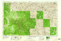
~ Rolla MO topo map, 1:250000 scale, 1 X 2 Degree, Historical, 1959, updated 1959
Rolla, Missouri, USGS topographic map dated 1959.
Includes geographic coordinates (latitude and longitude). This topographic map is suitable for hiking, camping, and exploring, or framing it as a wall map.
Printed on-demand using high resolution imagery, on heavy weight and acid free paper, or alternatively on a variety of synthetic materials.
Topos available on paper, Waterproof, Poly, or Tyvek. Usually shipping rolled, unless combined with other folded maps in one order.
- Product Number: USGS-5575920
- Free digital map download (high-resolution, GeoPDF): Rolla, Missouri (file size: 25 MB)
- Map Size: please refer to the dimensions of the GeoPDF map above
- Weight (paper map): ca. 55 grams
- Map Type: POD USGS Topographic Map
- Map Series: HTMC
- Map Verison: Historical
- Cell ID: 72245
- Scan ID: 325617
- Imprint Year: 1959
- Woodland Tint: Yes
- Field Check Year: 1954
- Datum: Unstated
- Map Projection: Transverse Mercator
- Map published by United States Army Corps of Engineers
- Map published by United States Army
- Map Language: English
- Scanner Resolution: 600 dpi
- Map Cell Name: Rolla
- Grid size: 1 X 2 Degree
- Date on map: 1959
- Map Scale: 1:250000
- Geographical region: Missouri, United States
Neighboring Maps:
All neighboring USGS topo maps are available for sale online at a variety of scales.
Spatial coverage:
Topo map Rolla, Missouri, covers the geographical area associated the following places:
- New Bourbon - Pilot Knob - Braddy Ford (historical) - Millcreek - Cook Station - Nagle - Junction City - Bunker - Derby - Millers - Dillard - Esther - Valley Forge (historical) - The Lead Belt - Chloride - Red Point - Varsh Ford - Tin Mountain - Dent - Klendike - Berryman - Irondale - Saco - Jonca - Bixby - Levy - Bessville - New Offenburg - Mineral Springs City - Redford - Graniteville - Greeley - Gaylor - Yukon - Wide Ford - Vulcan - Berryman - Huxie - Iron Mountain - Gladden - Viburnum - Platow - Cross Roads - Varvol - Wesco - Venice - Helvey (historical) - Damon - Highley Heights - Oakley - Hobson - Gila - Hurricane - Palmer - Brazil - Salem - Arab - Zalma - Belleview - Howes Mill - Silva - Cherry Valley - Summit - Glover - Austria (historical) - Head Ford (historical) - Bangert - Settletown - Alamode (historical) - Pinkley (historical) - Four Points - Sabula - Frogtown - Hahn - Prescott - Yancy Mills - Cedar Ford - McGee - Kinderpost - English Town - Cardinal Acres - Saint Jude Acres - Junction Ferry - Meramec Springs (historical) - Cooksey - Fountain Farm - Shawne - Oakside - Black - Belgrade - Gang - Raftville (historical) - Mineral City - River aux Vases - Service - Mill - Middlebrook - Shirley - Ohlman - Shrum
- Map Area ID: AREA3837-92-90
- Northwest corner Lat/Long code: USGSNW38-92
- Northeast corner Lat/Long code: USGSNE38-90
- Southwest corner Lat/Long code: USGSSW37-92
- Southeast corner Lat/Long code: USGSSE37-90
- Northern map edge Latitude: 38
- Southern map edge Latitude: 37
- Western map edge Longitude: -92
- Eastern map edge Longitude: -90


