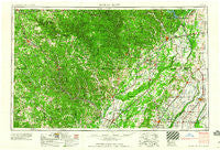
~ Poplar Bluff MO topo map, 1:250000 scale, 1 X 2 Degree, Historical, 1960, updated 1960
Poplar Bluff, Missouri, USGS topographic map dated 1960.
Includes geographic coordinates (latitude and longitude). This topographic map is suitable for hiking, camping, and exploring, or framing it as a wall map.
Printed on-demand using high resolution imagery, on heavy weight and acid free paper, or alternatively on a variety of synthetic materials.
Topos available on paper, Waterproof, Poly, or Tyvek. Usually shipping rolled, unless combined with other folded maps in one order.
- Product Number: USGS-5575906
- Free digital map download (high-resolution, GeoPDF): Poplar Bluff, Missouri (file size: 22 MB)
- Map Size: please refer to the dimensions of the GeoPDF map above
- Weight (paper map): ca. 55 grams
- Map Type: POD USGS Topographic Map
- Map Series: HTMC
- Map Verison: Historical
- Cell ID: 74976
- Scan ID: 325610
- Imprint Year: 1960
- Woodland Tint: Yes
- Field Check Year: 1957
- Datum: Unstated
- Map Projection: Transverse Mercator
- Map published by United States Army Corps of Engineers
- Map published by United States Army
- Map Language: English
- Scanner Resolution: 600 dpi
- Map Cell Name: Poplar Bluff
- Grid size: 1 X 2 Degree
- Date on map: 1960
- Map Scale: 1:250000
- Geographical region: Missouri, United States
Neighboring Maps:
All neighboring USGS topo maps are available for sale online at a variety of scales.
Spatial coverage:
Topo map Poplar Bluff, Missouri, covers the geographical area associated the following places:
- Kings Mills (historical) - Powe - Cornertown - Lone Hill - Halloran - Keener Cave - Dale - Hornersville - Mounds - Larkin - Royal Oak - Oxly - Lebo - Finch - Curdton - Farewell - Jesup - Chapel - Martinsburg (historical) - Sitka - Heart - Franklin - Bradyville (historical) - Powhatan - Camp Ground - Baker Ford - Pratt - Center - Pollard - Homeland - Gilbert - Shady Grove - LaCrosse - Lorine - Beaverdam - Fanchon - College City - Calamine - Rector - Cyrus - Castorville (historical) - Balboa (historical) - Billmore - Stuart - Beech Grove - Gibson - Brush Arbor - Supply - Midway - Myron - Hogan - Byron - Wenstead (historical) - Green Forest - Brandsville - Baird - Evening Star - Birch Tree - Tipperary - Camp - Stokes - Trinnon - Cockrum - Bennett - Tucker - Paulding - Calm - Bridgeport (historical) - Milltown - Corning - Neelyville - Corona - Rock Hill - Moark - Brakebill - Minorca - Acorn Ridge - Bull Run Camp - Woodside - Barron - Lanton - Parks - Hollywood - Hoxie - Gainesville - Guiteau - Fender - Piggott - West Plains - Montier - Fontaine - Kelly Town - Braswell - Portia - Budapest - Ladero - Old Siloam - Whitaker Place - Green Town - Quercus
- Map Area ID: AREA3736-92-90
- Northwest corner Lat/Long code: USGSNW37-92
- Northeast corner Lat/Long code: USGSNE37-90
- Southwest corner Lat/Long code: USGSSW36-92
- Southeast corner Lat/Long code: USGSSE36-90
- Northern map edge Latitude: 37
- Southern map edge Latitude: 36
- Western map edge Longitude: -92
- Eastern map edge Longitude: -90

