
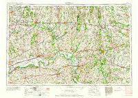
~ Moberly MO topo map, 1:250000 scale, 1 X 2 Degree, Historical, 1960, updated 1960
Moberly, Missouri, USGS topographic map dated 1960.
Includes geographic coordinates (latitude and longitude). This topographic map is suitable for hiking, camping, and exploring, or framing it as a wall map.
Printed on-demand using high resolution imagery, on heavy weight and acid free paper, or alternatively on a variety of synthetic materials.
Topos available on paper, Waterproof, Poly, or Tyvek. Usually shipping rolled, unless combined with other folded maps in one order.
- Product Number: USGS-5575902
- Free digital map download (high-resolution, GeoPDF): Moberly, Missouri (file size: 22 MB)
- Map Size: please refer to the dimensions of the GeoPDF map above
- Weight (paper map): ca. 55 grams
- Map Type: POD USGS Topographic Map
- Map Series: HTMC
- Map Verison: Historical
- Cell ID: 68916
- Scan ID: 325608
- Imprint Year: 1960
- Woodland Tint: Yes
- Field Check Year: 1954
- Datum: Unstated
- Map Projection: Transverse Mercator
- Map published by United States Geological Survey
- Map published by: Military, Other
- Map Language: English
- Scanner Resolution: 600 dpi
- Map Cell Name: Moberly
- Grid size: 1 X 2 Degree
- Date on map: 1960
- Map Scale: 1:250000
- Geographical region: Missouri, United States
Neighboring Maps:
All neighboring USGS topo maps are available for sale online at a variety of scales.
Spatial coverage:
Topo map Moberly, Missouri, covers the geographical area associated the following places:
- Harmony (historical) - Kern - Indian Grove - Goldsberry - Burton - Browns - Grand River City (historical) - Orearville - Triplett - Bowdry (historical) - Everett (historical) - Corner Campbell School - Levick Mill - Sharon - New Boston - Wilhite (historical) - Malta Bend - Breckenridge - Wheeling - Sturges - Cazzell - Hebron - Fayette - Rucker - Braymer - Judd - Hagers Grove - Steinmetz - Bethel - Punkin Center - Millville - Grand Port - Hickory Creek - Alpha - Murry - Moberly - Morton - Leopolis (historical) - Chula - Bedford - Axtell - Whitham - West Glasgow - Mayview - Alma - Montague Hill - Herndon - Fowkes - Namrash (historical) - Mooresville - Bear Branch - Urbandale - Marshall - Linneus - Carlow - Wilton Springs - Sebree - Leonard - Ryder - Darksville - Germantown (historical) - Oil City - Napton - Hodge - Roanoke - Hart - Dalton - Bunker Hill - Saint Catharine - Middleton - Bosworth - Coloma - Aullville - South Carrollton - Plainview - Newhall - Jacksonville - Jamesport - Huntsville - Leverton - Standish - Points (historical) - Lock Springs - Callao - Miles Point - Clarence - Shelby - Thralls Prairie (historical) - Shackleford - Macon - Wabash Crossing - De Witt - Lexington (historical) - Simpson - Slater - Excello - Henrietta - Salt Springs - Cottage - Shelbina
- Map Area ID: AREA4039-94-92
- Northwest corner Lat/Long code: USGSNW40-94
- Northeast corner Lat/Long code: USGSNE40-92
- Southwest corner Lat/Long code: USGSSW39-94
- Southeast corner Lat/Long code: USGSSE39-92
- Northern map edge Latitude: 40
- Southern map edge Latitude: 39
- Western map edge Longitude: -94
- Eastern map edge Longitude: -92


