
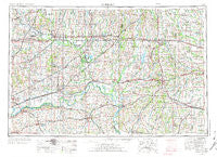
~ Moberly MO topo map, 1:250000 scale, 1 X 2 Degree, Historical, 1954, updated 1973
Moberly, Missouri, USGS topographic map dated 1954.
Includes geographic coordinates (latitude and longitude). This topographic map is suitable for hiking, camping, and exploring, or framing it as a wall map.
Printed on-demand using high resolution imagery, on heavy weight and acid free paper, or alternatively on a variety of synthetic materials.
Topos available on paper, Waterproof, Poly, or Tyvek. Usually shipping rolled, unless combined with other folded maps in one order.
- Product Number: USGS-5575896
- Free digital map download (high-resolution, GeoPDF): Moberly, Missouri (file size: 21 MB)
- Map Size: please refer to the dimensions of the GeoPDF map above
- Weight (paper map): ca. 55 grams
- Map Type: POD USGS Topographic Map
- Map Series: HTMC
- Map Verison: Historical
- Cell ID: 68916
- Scan ID: 325605
- Imprint Year: 1973
- Woodland Tint: Yes
- Visual Version Number: 1
- Aerial Photo Year: 1952
- Edit Year: 1970
- Field Check Year: 1954
- Datum: Unstated
- Map Projection: Transverse Mercator
- Map published by United States Geological Survey
- Map published by: Military, Other
- Map Language: English
- Scanner Resolution: 600 dpi
- Map Cell Name: Moberly
- Grid size: 1 X 2 Degree
- Date on map: 1954
- Map Scale: 1:250000
- Geographical region: Missouri, United States
Neighboring Maps:
All neighboring USGS topo maps are available for sale online at a variety of scales.
Spatial coverage:
Topo map Moberly, Missouri, covers the geographical area associated the following places:
- Judd - Points (historical) - Hickory Creek - Murry - Rockingham - Blackburn - Wilton Springs - Bonanza - Cream Ridge - Narrows Creek (historical) - Snow (historical) - Leonard - Petersburg - Keytesville - Milford - Alma - Shoal - New Franklin - New York - Stapletown (historical) - Snyder - Slater - Chraneville (historical) - Chula - Mendon - Wellington - Middleton - Dover - Petersburg (historical) - Cambridge - Ludlow - Levick Mill - Everett (historical) - New Boston - Granville - Eversonville - Lock Springs - Kern - Redman - Montague Hill - Shelby - Wheeling - Cox - Tulip - Oil City - Goldsberry - Middle Grove - Mercyville - Louisville - Fortyville (historical) - Marshall - Forker - Lexington (historical) - Proctorville - Lebanon (historical) - Lexington - Hodge - Blue Lick - Norville - Orearville - Myrick - Mayview - Cairo - Rockford - Goodland - Maud - Kellogg - Darksville - Lowell - Laclede - Purdin - Hebron - Harrisburg - Fisher (historical) - Lisbon - Dockery - Clifton Hill - Anabel - Standish - Number Eight - Springhill - Woodlandville - Sebree - Sharon - Newhall - Higginsville - Harkes - Hallsville - Little Osage Village (historical) - Blake - Keota - Waverly - Punkin Center - Little Compton - Ryder - Ovid (historical) - New Cambria - Stephens - Corder - Sue City
- Map Area ID: AREA4039-94-92
- Northwest corner Lat/Long code: USGSNW40-94
- Northeast corner Lat/Long code: USGSNE40-92
- Southwest corner Lat/Long code: USGSSW39-94
- Southeast corner Lat/Long code: USGSSE39-92
- Northern map edge Latitude: 40
- Southern map edge Latitude: 39
- Western map edge Longitude: -94
- Eastern map edge Longitude: -92


