
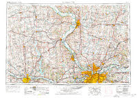
~ Kansas City MO topo map, 1:250000 scale, 1 X 2 Degree, Historical, 1956, updated 1976
Kansas City, Missouri, USGS topographic map dated 1956.
Includes geographic coordinates (latitude and longitude). This topographic map is suitable for hiking, camping, and exploring, or framing it as a wall map.
Printed on-demand using high resolution imagery, on heavy weight and acid free paper, or alternatively on a variety of synthetic materials.
Topos available on paper, Waterproof, Poly, or Tyvek. Usually shipping rolled, unless combined with other folded maps in one order.
- Product Number: USGS-5575890
- Free digital map download (high-resolution, GeoPDF): Kansas City, Missouri (file size: 23 MB)
- Map Size: please refer to the dimensions of the GeoPDF map above
- Weight (paper map): ca. 55 grams
- Map Type: POD USGS Topographic Map
- Map Series: HTMC
- Map Verison: Historical
- Cell ID: 68851
- Scan ID: 325602
- Imprint Year: 1976
- Woodland Tint: Yes
- Visual Version Number: 1
- Aerial Photo Year: 1973
- Edit Year: 1974
- Field Check Year: 1956
- Datum: Unstated
- Map Projection: Transverse Mercator
- Map published by United States Geological Survey
- Map published by: Military, Other
- Map Language: English
- Scanner Resolution: 600 dpi
- Map Cell Name: Kansas City
- Grid size: 1 X 2 Degree
- Date on map: 1956
- Map Scale: 1:250000
- Geographical region: Missouri, United States
Neighboring Maps:
All neighboring USGS topo maps are available for sale online at a variety of scales.
Spatial coverage:
Topo map Kansas City, Missouri, covers the geographical area associated the following places:
- Fairport - Coldspur - Kenmoor - Cosby - Medina - Ravena Gardens - Wadsworth - Barnesville - Mock Corner - Faucett - Lake Ridge - Coopers - Bendena - Bern - Lake City - Winthrop - Centropolis - Napoleon - Topeka - Agency - Fidelity - Hoover - North Valley Mobile Home Village - Country Hills Manufactured Home Community - Grandview - South Basehor - Clevenger - Atherton - Creekside Estates Mobile Home Park - Kerrville - Ectonville - Hamlin - Sunflower Village Mobile Home Park - San Antonio - Prairie Ridge - Atchison - Buckner - Matney - Bean Lake Station - Half Mound - Scearces - Big Springs - Saint Pats - Min - Rock Village - Beverly Hills - Lancaster - Piper - Forbes - Amity - Haydite - Fountainbleau - Sibley - Grayson - Farmington - Effingham - Sugar Lake - Houston Lake - Blue Springs - Prathersville - Maysville - S and J Estates Mobile Home Park - Evanston - Starfield - Chouteau - Trimble - Fairway - Valley Falls - Dye - Curzon - Brittany Place Mobile Home Park - Mecca - Raytown - Wetmore - Winner - Clarksdale - Purcell - Westbridge - Lakeside Village - Northview Mobile Home Park - Independence - Missouri City - Whiting - Rayville - Sunflower Trailer Park - Golf Hill - Kickapoo - Stone - Elwood - Richville - Lilly - Halleck - Highland Park - Lake Station - Gower - Easton - Oakwood - Claysville - Vibbard - Five Points - Valencia
- Map Area ID: AREA4039-96-94
- Northwest corner Lat/Long code: USGSNW40-96
- Northeast corner Lat/Long code: USGSNE40-94
- Southwest corner Lat/Long code: USGSSW39-96
- Southeast corner Lat/Long code: USGSSE39-94
- Northern map edge Latitude: 40
- Southern map edge Latitude: 39
- Western map edge Longitude: -96
- Eastern map edge Longitude: -94


