
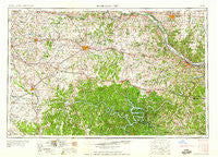
~ Jefferson City MO topo map, 1:250000 scale, 1 X 2 Degree, Historical, 1959, updated 1959
Jefferson City, Missouri, USGS topographic map dated 1959.
Includes geographic coordinates (latitude and longitude). This topographic map is suitable for hiking, camping, and exploring, or framing it as a wall map.
Printed on-demand using high resolution imagery, on heavy weight and acid free paper, or alternatively on a variety of synthetic materials.
Topos available on paper, Waterproof, Poly, or Tyvek. Usually shipping rolled, unless combined with other folded maps in one order.
- Product Number: USGS-5575858
- Free digital map download (high-resolution, GeoPDF): Jefferson City, Missouri (file size: 24 MB)
- Map Size: please refer to the dimensions of the GeoPDF map above
- Weight (paper map): ca. 55 grams
- Map Type: POD USGS Topographic Map
- Map Series: HTMC
- Map Verison: Historical
- Cell ID: 68843
- Scan ID: 325587
- Imprint Year: 1959
- Woodland Tint: Yes
- Aerial Photo Year: 1950
- Field Check Year: 1955
- Datum: Unstated
- Map Projection: Transverse Mercator
- Map published by United States Army Corps of Engineers
- Map published by United States Army
- Map Language: English
- Scanner Resolution: 600 dpi
- Map Cell Name: Jefferson City
- Grid size: 1 X 2 Degree
- Date on map: 1959
- Map Scale: 1:250000
- Geographical region: Missouri, United States
Neighboring Maps:
All neighboring USGS topo maps are available for sale online at a variety of scales.
Spatial coverage:
Topo map Jefferson City, Missouri, covers the geographical area associated the following places:
- Meyerstown - Toronto - Pisgah - Koeltztown - Wilton - Robbins - Pilot Grove - Macks Camp - Venus - Pierpont - Saint Martins - Boonville - Tuscumbia - Sweet Springs - Old Linn Creek - Sagrada - Crockerville - Earl - Shawnee Mound - Castle Rock (historical) - Brazito - Moores Switch - Shantytown - Neongwah - Opportunity Farms - Norris - Cole Camp Junction - Palo Pinto - High Point - Brumley - Bellair - Windsor - Harriston - Quarles - Longwood - Knob Noster - Livingston - Midway - Tedieville - Emma - Alberta - Smithton (historical) - Billingsville - Browns Ford - Aurora Springs - Mount Pleasant - Clifton City - Fox Run - Green Bay Terrace - Walkers Corner - Lisletown (historical) - Hastain - Easley - Quincy - Cold Springs - New Lebanon - Damsel - Chouteau Springs - Santiago - Lamine - Millers - Gravois Mills - Blue Branch - Big Bend - Monegaw Springs - Ionia - Dell Junction - Valley View - Lakeview Heights - Lincoln - Phillips Ford (historical) - Brays - Boydsville - Wooldridge - Fortuna - Freedom - Scrivner - Carrington - Atwell - Versailles - Millersburg - Bass - Chloe - Greendoor - Cole Junction - Marion - Bacon - Blackwater (historical) - Leeton - Kliever - Saint Elizabeth - Traderight - Hoecker - Hoffman - Bentonville - Pom-o-sa Heights - Kaiser - Todd (historical) - Crittenden (historical) - Centertown
- Map Area ID: AREA3938-94-92
- Northwest corner Lat/Long code: USGSNW39-94
- Northeast corner Lat/Long code: USGSNE39-92
- Southwest corner Lat/Long code: USGSSW38-94
- Southeast corner Lat/Long code: USGSSE38-92
- Northern map edge Latitude: 39
- Southern map edge Latitude: 38
- Western map edge Longitude: -94
- Eastern map edge Longitude: -92


