
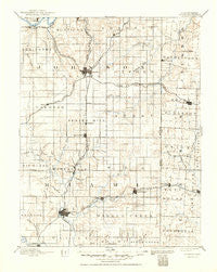
~ Olathe KS topo map, 1:125000 scale, 30 X 30 Minute, Historical, 1893, updated 1950
Olathe, Kansas, USGS topographic map dated 1893.
Includes geographic coordinates (latitude and longitude). This topographic map is suitable for hiking, camping, and exploring, or framing it as a wall map.
Printed on-demand using high resolution imagery, on heavy weight and acid free paper, or alternatively on a variety of synthetic materials.
Topos available on paper, Waterproof, Poly, or Tyvek. Usually shipping rolled, unless combined with other folded maps in one order.
- Product Number: USGS-5575766
- Free digital map download (high-resolution, GeoPDF): Olathe, Kansas (file size: 7 MB)
- Map Size: please refer to the dimensions of the GeoPDF map above
- Weight (paper map): ca. 55 grams
- Map Type: POD USGS Topographic Map
- Map Series: HTMC
- Map Verison: Historical
- Cell ID: 66241
- Scan ID: 325540
- Imprint Year: 1950
- Survey Year: 1885
- Datum: Unstated
- Map Projection: Polyconic
- Map published by United States Geological Survey
- Map Language: English
- Scanner Resolution: 600 dpi
- Map Cell Name: Olathe
- Grid size: 30 X 30 Minute
- Date on map: 1893
- Map Scale: 1:125000
- Geographical region: Kansas, United States
Neighboring Maps:
All neighboring USGS topo maps are available for sale online at a variety of scales.
Spatial coverage:
Topo map Olathe, Kansas, covers the geographical area associated the following places:
- Cleveland - De Soto - Martin City - Stilwell - Truman Corners - Overland Park - New Santa Fe - Marlborough - Monticello - Leawood - Lackmans - Loch Lloyd - Grandview - Warsop Mobile Home Park - Wagstaff - Hillsdale - Bosworth Mobile Home Park - Belvidere - Craig - Santa Barbara Mobile Home Park - Hickman Mills - Louisburg Manufactured Home Estates - Somerset - Paola - Chiles - Melville - Dodson - Ponchos Mobile Home Park - Lenexa - Block - Lenape - Jeffreys - Olson Acres - Elmhurst - Riverview Estates - Kenneth - Pingleton Mobile Home Park - Waldo - Bonita - Jaudon - Lisle - Wea - De Soto Mobile Home Park - Flinn - Freeman - Oasis Mobile Home Park - Louisburg - Olathe - Lento - Bucyrus - B And L Mobile Home Park - Red Bridge - Ruskin Heights - Ocheltree - Hometown Santa Barbara Mobile Home Park - Prairie Village - Spring Hill - Conestoga Estates Mobile Home Park - Ruskin - Ringer - West Line - Redel - Antioch - Stanley - Lake Annette - Indian Village - Morse - Dallas - Paola Mobile Home Park - Gardner - Belton - Cedar - Holmes Park - Henson - Bryant - Aubry - Clare
- Map Area ID: AREA3938.5-95-94.5
- Northwest corner Lat/Long code: USGSNW39-95
- Northeast corner Lat/Long code: USGSNE39-94.5
- Southwest corner Lat/Long code: USGSSW38.5-95
- Southeast corner Lat/Long code: USGSSE38.5-94.5
- Northern map edge Latitude: 39
- Southern map edge Latitude: 38.5
- Western map edge Longitude: -95
- Eastern map edge Longitude: -94.5


