
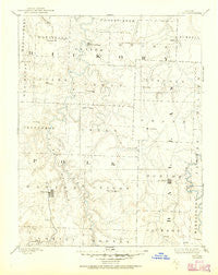
~ Bolivar MO topo map, 1:125000 scale, 30 X 30 Minute, Historical, 1892, updated 1950
Bolivar, Missouri, USGS topographic map dated 1892.
Includes geographic coordinates (latitude and longitude). This topographic map is suitable for hiking, camping, and exploring, or framing it as a wall map.
Printed on-demand using high resolution imagery, on heavy weight and acid free paper, or alternatively on a variety of synthetic materials.
Topos available on paper, Waterproof, Poly, or Tyvek. Usually shipping rolled, unless combined with other folded maps in one order.
- Product Number: USGS-5575528
- Free digital map download (high-resolution, GeoPDF): Bolivar, Missouri (file size: 5 MB)
- Map Size: please refer to the dimensions of the GeoPDF map above
- Weight (paper map): ca. 55 grams
- Map Type: POD USGS Topographic Map
- Map Series: HTMC
- Map Verison: Historical
- Cell ID: 65026
- Scan ID: 325413
- Imprint Year: 1950
- Survey Year: 1884
- Datum: NAD
- Map Projection: Polyconic
- Map published by United States Geological Survey
- Map Language: English
- Scanner Resolution: 600 dpi
- Map Cell Name: Bolivar
- Grid size: 30 X 30 Minute
- Date on map: 1892
- Map Scale: 1:125000
- Geographical region: Missouri, United States
Neighboring Maps:
All neighboring USGS topo maps are available for sale online at a variety of scales.
Spatial coverage:
Topo map Bolivar, Missouri, covers the geographical area associated the following places:
- Charity - Polk - Hico (historical) - Louisburg - Cedar Vista - Almon - Schofield - Burns - Clifford (historical) - Foose - Branch - Rimby - Mohawk Corner - Violet - Rex - Ingalls (historical) - Wheatland - Pumpkin Center - Tunas - Reynolds - Wood Hill - Elixer - March - Redtop - Hermitage - Galmey - Bolivar - Goodson - Huckaby - Spring Grove - Buffalo - Adonis - Cloverdale - Sentinel - Preston - Slagle - Carsons Corner - Huron - Boyd - Pittsburg - Karlin - Butcher - Dewey (historical) - Nemo - Halfway - Urbana - Cliquot - Rondo - Sunset - Mathis - Wishart - Van - Elkton
- Map Area ID: AREA3837.5-93.5-93
- Northwest corner Lat/Long code: USGSNW38-93.5
- Northeast corner Lat/Long code: USGSNE38-93
- Southwest corner Lat/Long code: USGSSW37.5-93.5
- Southeast corner Lat/Long code: USGSSE37.5-93
- Northern map edge Latitude: 38
- Southern map edge Latitude: 37.5
- Western map edge Longitude: -93.5
- Eastern map edge Longitude: -93


