
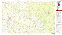
~ West Plains MO topo map, 1:100000 scale, 30 X 60 Minute, Historical, 1984, updated 1984
West Plains, Missouri, USGS topographic map dated 1984.
Includes geographic coordinates (latitude and longitude). This topographic map is suitable for hiking, camping, and exploring, or framing it as a wall map.
Printed on-demand using high resolution imagery, on heavy weight and acid free paper, or alternatively on a variety of synthetic materials.
Topos available on paper, Waterproof, Poly, or Tyvek. Usually shipping rolled, unless combined with other folded maps in one order.
- Product Number: USGS-5575522
- Free digital map download (high-resolution, GeoPDF): West Plains, Missouri (file size: 20 MB)
- Map Size: please refer to the dimensions of the GeoPDF map above
- Weight (paper map): ca. 55 grams
- Map Type: POD USGS Topographic Map
- Map Series: HTMC
- Map Verison: Historical
- Cell ID: 68572
- Scan ID: 325410
- Imprint Year: 1984
- Woodland Tint: Yes
- Aerial Photo Year: 1978
- Edit Year: 1984
- Datum: NAD27
- Map Projection: Universal Transverse Mercator
- Planimetric: Yes
- Map published by United States Geological Survey
- Map Language: English
- Scanner Resolution: 600 dpi
- Map Cell Name: West Plains
- Grid size: 30 X 60 Minute
- Date on map: 1984
- Map Scale: 1:100000
- Geographical region: Missouri, United States
Neighboring Maps:
All neighboring USGS topo maps are available for sale online at a variety of scales.
Spatial coverage:
Topo map West Plains, Missouri, covers the geographical area associated the following places:
- Globe - Myrtle - Riverton - Allen Ford - Fremont - Moody - Summers Addition - Corona - Fruitville - Cottbus - Koshkonong - China - McFry Ford - Barren (historical) - Chapel - Calm - Burnham - Garfield - Lebo - West Plains - Sloan Ford - Culp Ford - Lanton - Braswell - Couch - Low Wassie - Chicopee - White Church - Hollis - Clifton - Mott (historical) - Guiteau - Jeff - Tucker - Hutton Valley - Bardley - Bennett - Brandsville - Willow Springs - Hunter Crossing - Simpson - South Van Buren - Birch Tree - Huddleston - Rover - Carson (historical) - Thayer - Royal Oak - South Fork - Jobe - Old Town - Alton - Homeland - Not - Van Buren - Elliot Ford - Handy - Turners Mill - Ross (historical) - Pocohontas Crossing - Fanchon - Woodside - Lulu - Jobe (historical) - Greer - Trask - Billmore - Midway - Congo (historical) - Thomasville - Montier - Wilderness - Green Town - Eastwood - Teresita - Farewell - Griswold - Cull - New Liberty - Boze Mill - Brawley - Shelby - Mountain View - Olden - Deckard-Y - Pomona - Frankville - Gatewood - Peace Valley - Chapin
- Map Area ID: AREA3736.5-92-91
- Northwest corner Lat/Long code: USGSNW37-92
- Northeast corner Lat/Long code: USGSNE37-91
- Southwest corner Lat/Long code: USGSSW36.5-92
- Southeast corner Lat/Long code: USGSSE36.5-91
- Northern map edge Latitude: 37
- Southern map edge Latitude: 36.5
- Western map edge Longitude: -92
- Eastern map edge Longitude: -91


