
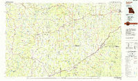
~ Sullivan MO topo map, 1:100000 scale, 30 X 60 Minute, Historical, 1985, updated 1985
Sullivan, Missouri, USGS topographic map dated 1985.
Includes geographic coordinates (latitude and longitude). This topographic map is suitable for hiking, camping, and exploring, or framing it as a wall map.
Printed on-demand using high resolution imagery, on heavy weight and acid free paper, or alternatively on a variety of synthetic materials.
Topos available on paper, Waterproof, Poly, or Tyvek. Usually shipping rolled, unless combined with other folded maps in one order.
- Product Number: USGS-5575514
- Free digital map download (high-resolution, GeoPDF): Sullivan, Missouri (file size: 21 MB)
- Map Size: please refer to the dimensions of the GeoPDF map above
- Weight (paper map): ca. 55 grams
- Map Type: POD USGS Topographic Map
- Map Series: HTMC
- Map Verison: Historical
- Cell ID: 68421
- Scan ID: 325406
- Imprint Year: 1985
- Woodland Tint: Yes
- Aerial Photo Year: 1983
- Edit Year: 1985
- Datum: NAD27
- Map Projection: Universal Transverse Mercator
- Planimetric: Yes
- Map published by United States Geological Survey
- Map Language: English
- Scanner Resolution: 600 dpi
- Map Cell Name: Sullivan
- Grid size: 30 X 60 Minute
- Date on map: 1985
- Map Scale: 1:100000
- Geographical region: Missouri, United States
Neighboring Maps:
All neighboring USGS topo maps are available for sale online at a variety of scales.
Spatial coverage:
Topo map Sullivan, Missouri, covers the geographical area associated the following places:
- Hinch - Krakow - Drewel Ford (historical) - Saint Cloud - Byron - Laubinger Ford - Walbert (historical) - Oak Grove Village - Wiffenberg - Koenig - Gerald - Schundler - Bend - Ryors - Johnson Ford (historical) - Paydown Ford (historical) - Mount Sterling - Noser Mill - Vilander - Jake Prairie - Broadway (historical) - Caseyville - Vienna - Monday - Potts - Miramiguoa Park - James Brothers - Beaufort - Westphalia - High Gate - Champion City - Argo - Fox Springs - Bland - Neier - Tea - Suelthaus Ford - Stanton - Drake - Canaan - New Woollam - Paydown - Twin Springs - Old Bland - Lindell - Sullivan - Iron Center - Hayden - Linn - Glaser Ford - Delhi - Valentine Ford - Belle - Anthonies Mill - Pea Ridge - Davis Ford - Millrock Ford - Freedom - Jeffriesburg - Feuersville (historical) - Scotia - Greenstreet - Summerfield - Spring Bluff - Lois - Cooper Hill - Dingley (historical) - Cuba - Sewell Ford - Hulsey - Flag Spring - Witte Ford (historical) - Gaines Ford (historical) - Safe - Avery (historical) - Oak Hill - Cave Hill - Strain - Leasburg - Owensville - Port Hudson - Leslie - Benson Tourist City - Royal - West Sullivan - Coffeyton - Anaconda - Freeburg - Jaegers Shop - Harrison Mills - Beemont - Crossroads - Bem - Leduc (historical) - Boone (historical) - Arthur Spring Ford - Amanda - Redbird - Vieman (historical) - Cleavesville
- Map Area ID: AREA38.538-92-91
- Northwest corner Lat/Long code: USGSNW38.5-92
- Northeast corner Lat/Long code: USGSNE38.5-91
- Southwest corner Lat/Long code: USGSSW38-92
- Southeast corner Lat/Long code: USGSSE38-91
- Northern map edge Latitude: 38.5
- Southern map edge Latitude: 38
- Western map edge Longitude: -92
- Eastern map edge Longitude: -91


