
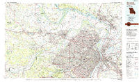
~ St Louis MO topo map, 1:100000 scale, 30 X 60 Minute, Historical, 1985, updated 1985
St Louis, Missouri, USGS topographic map dated 1985.
Includes geographic coordinates (latitude and longitude). This topographic map is suitable for hiking, camping, and exploring, or framing it as a wall map.
Printed on-demand using high resolution imagery, on heavy weight and acid free paper, or alternatively on a variety of synthetic materials.
Topos available on paper, Waterproof, Poly, or Tyvek. Usually shipping rolled, unless combined with other folded maps in one order.
- Product Number: USGS-5575508
- Free digital map download (high-resolution, GeoPDF): St Louis, Missouri (file size: 31 MB)
- Map Size: please refer to the dimensions of the GeoPDF map above
- Weight (paper map): ca. 55 grams
- Map Type: POD USGS Topographic Map
- Map Series: HTMC
- Map Verison: Historical
- Cell ID: 68283
- Scan ID: 325403
- Imprint Year: 1985
- Woodland Tint: Yes
- Aerial Photo Year: 1983
- Edit Year: 1985
- Datum: NAD27
- Map Projection: Universal Transverse Mercator
- Planimetric: Yes
- Map published by United States Geological Survey
- Map Language: English
- Scanner Resolution: 600 dpi
- Map Cell Name: Saint Louis
- Grid size: 30 X 60 Minute
- Date on map: 1985
- Map Scale: 1:100000
- Geographical region: Missouri, United States
Neighboring Maps:
All neighboring USGS topo maps are available for sale online at a variety of scales.
Spatial coverage:
Topo map St Louis, Missouri, covers the geographical area associated the following places:
- Spanish Lake - National City - Moline Acres - Rosemont - Greendale - McKinley Heights - Benton - Great Oaks - Schuermann Heights - Central West End - Covenant Blu-Grand Center - Winchester - Union Hill - Beechville - Maplewood Park - Fountains at Bear Creek - Loehr - Saint Paul - O'Fallon - Rosedale - Centerville - Gartside - Imbs - State Park Place - Crystal Lake Park - Chautauqua - Rock Springs - Earth City - Sauget - Marina Villa - Ballwin - Maryland Place - Frontenac - Kinloch - Southmoor - Benton Park West - Hilltop - Petersville - Westview - South Troy - Ivy Heights - Hazelwood - Mary Ridge - Machens - Black Jack - Belmont Village - Richmond Heights - Woodhine Heights - Seebarger - Dupo - Saint Albans - Cool Valley - Rock Hill - Weldon Spring Heights - Larimore - Gumbo - Champ - Pettys Hill - Centreville - Country Life Acres - Hi-Pointe - Granite City - Shaw - Rose Lake - Velda Village - Sherman - Near North Riverfront - Orrville - University City - Owen (historical) - Vulcan - Oetters - Cheltenham - Peine Woods - Cross Keys - Olivette - Greater Ville - Woodlands at Bear Creek - Godfrey - Country Club Hills - Fox Park - Pasadena Park - Four Corners - Crescent - Augusta - Caseyville - Musicks Ferry - Maryland Heights - Cedar Park - Saint George - Dutch Hollow - Avery Hill - Jacobs - La Charbonniere (historical) - South Shore - Wellston - Jeff Vander Lou - Briar Hill - Woods - Highview (historical)
- Map Area ID: AREA3938.5-91-90
- Northwest corner Lat/Long code: USGSNW39-91
- Northeast corner Lat/Long code: USGSNE39-90
- Southwest corner Lat/Long code: USGSSW38.5-91
- Southeast corner Lat/Long code: USGSSE38.5-90
- Northern map edge Latitude: 39
- Southern map edge Latitude: 38.5
- Western map edge Longitude: -91
- Eastern map edge Longitude: -90


