
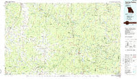
~ Spring Valley MO topo map, 1:100000 scale, 30 X 60 Minute, Historical, 1986, updated 1986
Spring Valley, Missouri, USGS topographic map dated 1986.
Includes geographic coordinates (latitude and longitude). This topographic map is suitable for hiking, camping, and exploring, or framing it as a wall map.
Printed on-demand using high resolution imagery, on heavy weight and acid free paper, or alternatively on a variety of synthetic materials.
Topos available on paper, Waterproof, Poly, or Tyvek. Usually shipping rolled, unless combined with other folded maps in one order.
- Product Number: USGS-5575500
- Free digital map download (high-resolution, GeoPDF): Spring Valley, Missouri (file size: 22 MB)
- Map Size: please refer to the dimensions of the GeoPDF map above
- Weight (paper map): ca. 55 grams
- Map Type: POD USGS Topographic Map
- Map Series: HTMC
- Map Verison: Historical
- Cell ID: 68397
- Scan ID: 325399
- Imprint Year: 1986
- Woodland Tint: Yes
- Aerial Photo Year: 1985
- Edit Year: 1986
- Datum: NAD27
- Map Projection: Universal Transverse Mercator
- Planimetric: Yes
- Map published by United States Geological Survey
- Map Language: English
- Scanner Resolution: 600 dpi
- Map Cell Name: Spring Valley
- Grid size: 30 X 60 Minute
- Date on map: 1986
- Map Scale: 1:100000
- Geographical region: Missouri, United States
Neighboring Maps:
All neighboring USGS topo maps are available for sale online at a variety of scales.
Spatial coverage:
Topo map Spring Valley, Missouri, covers the geographical area associated the following places:
- Rector - Hartshorn - Deslet - Gila - Midvale - Delaware - Hattie - Cardinal Acres - Samoa - Bee Fork - Eunice - Himont (historical) - Clear Springs - Solo - Houston - Eminence - Melton - Flatwood - Big Creek - Corridon - Rat - Buckhart Springs (historical) - Ashley Creek - Reynolds - Raymondville - Licking - Prescott - Alley Spring - Brushy Mill (historical) - Round Spring - Tyrone - Pine Crest - Oakdale (historical) - Nagle - Turnerville - Gladden - Jadwin - Ink - Guild - Venable - Venice - Munsell - West Bunker - Timber - Ratcliff Ford - Oakside - Gang - Varvol - Shawne - Raftville (historical) - Akers - Harlow Ford - West Eminence - Mahan - Elk Creek - Grogan - Spur 3 (historical) - Alley - Midridge - House Creek - Montauk - Owls Bend - Bunker - Shannondale - Mineral Springs City - Bedwell - Beal - Tin Roof (historical) - Bartlett - Arroll - West Fork - Sinkin (historical) - Falk Mill (historical) - Winona - Nile - Oscar - Summersville - Ohlman - Dairyville (historical) - Dagonia - House Hollow (historical) - Halcyon - Cedargrove - Fruit City - Mauser Mill - Junction Ferry - Yukon
- Map Area ID: AREA37.537-92-91
- Northwest corner Lat/Long code: USGSNW37.5-92
- Northeast corner Lat/Long code: USGSNE37.5-91
- Southwest corner Lat/Long code: USGSSW37-92
- Southeast corner Lat/Long code: USGSSE37-91
- Northern map edge Latitude: 37.5
- Southern map edge Latitude: 37
- Western map edge Longitude: -92
- Eastern map edge Longitude: -91


