
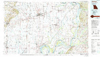
~ Sikeston MO topo map, 1:100000 scale, 30 X 60 Minute, Historical, 1985, updated 1994
Sikeston, Missouri, USGS topographic map dated 1985.
Includes geographic coordinates (latitude and longitude). This topographic map is suitable for hiking, camping, and exploring, or framing it as a wall map.
Printed on-demand using high resolution imagery, on heavy weight and acid free paper, or alternatively on a variety of synthetic materials.
Topos available on paper, Waterproof, Poly, or Tyvek. Usually shipping rolled, unless combined with other folded maps in one order.
- Product Number: USGS-5575498
- Free digital map download (high-resolution, GeoPDF): Sikeston, Missouri (file size: 23 MB)
- Map Size: please refer to the dimensions of the GeoPDF map above
- Weight (paper map): ca. 55 grams
- Map Type: POD USGS Topographic Map
- Map Series: HTMC
- Map Verison: Historical
- Cell ID: 68366
- Scan ID: 325398
- Imprint Year: 1994
- Woodland Tint: Yes
- Photo Inspection Year: 1990
- Aerial Photo Year: 1981
- Edit Year: 1985
- Datum: NAD27
- Map Projection: Universal Transverse Mercator
- Map published by United States Geological Survey
- Map Language: English
- Scanner Resolution: 600 dpi
- Map Cell Name: Sikeston
- Grid size: 30 X 60 Minute
- Date on map: 1985
- Map Scale: 1:100000
- Geographical region: Missouri, United States
Neighboring Maps:
All neighboring USGS topo maps are available for sale online at a variety of scales.
Spatial coverage:
Topo map Sikeston, Missouri, covers the geographical area associated the following places:
- Cody (historical) - Lilbourn - Broadwater - Berkley - Avert - Marco - Forest Spur - Crumpecker (historical) - Little River - Rumsey Spur (historical) - Bloomfield - Bluff - Nordlow (historical) - Ash Log - Toppertown - Norfolk (historical) - La Forge - Stubbs - Liberty (historical) - Dogwood - Vanduser - Risco - Scott - Essex - Clines Island - Fish Pond (historical) - Catron - Charleston - Morehouse - Tar Heel - East Prairie - Browns - Pinhook - Baderville - Hailwell - Whaynes Corner - Grayridge - Noxall - Tallapoosa - Samos - Pulltight - Coulter - Alfalfa Center - Hallett (historical) - Dorena - East Lake - Moss (historical) - Spoonerville - Wolf Island - Durnell - Ogden - Porter - Deventer - Farrenburg - Bardwell - Providence - Maulsby - Miller - Shady Dell - Circle City - Howardville - Anna Lynne - Townley - Parma - Champion - Anniston - Buckeye - Cayce - Dexter - South Columbus - Bernie - Bondurant - Juanita (historical) - Guam - Miner - Wickliffe - Bertrand - Laketon - Hondin (historical) - Rushs Ridge - Jordan - Zeta (historical) - Winford - Krepin (historical) - Mississippi (historical) - Walnut Grove (historical) - Greenfield - Mabel - Zadock - Airline Acres - Big Ridge - Catalpa - Crosno - Owens (historical) - Himmel - Blue Pond - Old Shawnee Village (historical) - Hills Store - Sargent - Otis
- Map Area ID: AREA3736.5-90-89
- Northwest corner Lat/Long code: USGSNW37-90
- Northeast corner Lat/Long code: USGSNE37-89
- Southwest corner Lat/Long code: USGSSW36.5-90
- Southeast corner Lat/Long code: USGSSE36.5-89
- Northern map edge Latitude: 37
- Southern map edge Latitude: 36.5
- Western map edge Longitude: -90
- Eastern map edge Longitude: -89


