
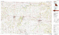
~ Sedalia MO topo map, 1:100000 scale, 30 X 60 Minute, Historical, 1983, updated 1983
Sedalia, Missouri, USGS topographic map dated 1983.
Includes geographic coordinates (latitude and longitude). This topographic map is suitable for hiking, camping, and exploring, or framing it as a wall map.
Printed on-demand using high resolution imagery, on heavy weight and acid free paper, or alternatively on a variety of synthetic materials.
Topos available on paper, Waterproof, Poly, or Tyvek. Usually shipping rolled, unless combined with other folded maps in one order.
- Product Number: USGS-5575496
- Free digital map download (high-resolution, GeoPDF): Sedalia, Missouri (file size: 27 MB)
- Map Size: please refer to the dimensions of the GeoPDF map above
- Weight (paper map): ca. 55 grams
- Map Type: POD USGS Topographic Map
- Map Series: HTMC
- Map Verison: Historical
- Cell ID: 68339
- Scan ID: 325397
- Imprint Year: 1983
- Woodland Tint: Yes
- Aerial Photo Year: 1980
- Edit Year: 1983
- Datum: NAD27
- Map Projection: Universal Transverse Mercator
- Map published by United States Geological Survey
- Map Language: English
- Scanner Resolution: 600 dpi
- Map Cell Name: Sedalia
- Grid size: 30 X 60 Minute
- Date on map: 1983
- Map Scale: 1:100000
- Geographical region: Missouri, United States
Neighboring Maps:
All neighboring USGS topo maps are available for sale online at a variety of scales.
Spatial coverage:
Topo map Sedalia, Missouri, covers the geographical area associated the following places:
- Spring Fork - Stokley - Blackwater (historical) - Bahner - Mount Olive - Shawnee Mound - Postal - Clifton City - Valley City - Bowmansville - Smithton - Norris - Oakland (historical) - Sedalia - Sutherland - Denton - Georgetown - Windsor - Owsley - Holden - Fayetteville - Columbus - Ernestville - Pipertown (historical) - Odessa - McAllister Springs - Bowen - Bryson - Robbins - Concordia - Petersburg - Marshall Junction - Lake Lafayette - Emma - Beaman - Carbon Hill - Brandon - Burtville - Sweet Springs - Green Ridge - Houstonia - Ridge Prairie - Greendoor - Mora - Pittsville - Dunksburg - Pertle Springs - Nelson - Montserrat - Centerview - Knob Noster - Ionia - Hoffman - La Monte - Blairstown - Otterville - Manila - Bristle Ridge - Leeton - Henrietta - Magnolia - Newland - Lake Creek - Tedieville - Warrensburg - Hughesville - Windsor Junction - Dresden - Cornelia - Pyrmont - Old Chilhowee - Wanamaker (historical) - Post Oak - Chilhowee - New Castle - Shackleford Crossing - Longwood
- Map Area ID: AREA3938.5-94-93
- Northwest corner Lat/Long code: USGSNW39-94
- Northeast corner Lat/Long code: USGSNE39-93
- Southwest corner Lat/Long code: USGSSW38.5-94
- Southeast corner Lat/Long code: USGSSE38.5-93
- Northern map edge Latitude: 39
- Southern map edge Latitude: 38.5
- Western map edge Longitude: -94
- Eastern map edge Longitude: -93


