
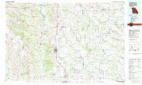
~ Kirksville MO topo map, 1:100000 scale, 30 X 60 Minute, Historical, 1981, updated 1982
Kirksville, Missouri, USGS topographic map dated 1981.
Includes geographic coordinates (latitude and longitude). This topographic map is suitable for hiking, camping, and exploring, or framing it as a wall map.
Printed on-demand using high resolution imagery, on heavy weight and acid free paper, or alternatively on a variety of synthetic materials.
Topos available on paper, Waterproof, Poly, or Tyvek. Usually shipping rolled, unless combined with other folded maps in one order.
- Product Number: USGS-5575460
- Free digital map download (high-resolution, GeoPDF): Kirksville, Missouri (file size: 25 MB)
- Map Size: please refer to the dimensions of the GeoPDF map above
- Weight (paper map): ca. 55 grams
- Map Type: POD USGS Topographic Map
- Map Series: HTMC
- Map Verison: Historical
- Cell ID: 67771
- Scan ID: 325376
- Imprint Year: 1982
- Woodland Tint: Yes
- Aerial Photo Year: 1978
- Edit Year: 1981
- Datum: NAD27
- Map Projection: Universal Transverse Mercator
- Map published by United States Geological Survey
- Map Language: English
- Scanner Resolution: 600 dpi
- Map Cell Name: Kirksville
- Grid size: 30 X 60 Minute
- Date on map: 1981
- Map Scale: 1:100000
- Geographical region: Missouri, United States
Neighboring Maps:
All neighboring USGS topo maps are available for sale online at a variety of scales.
Spatial coverage:
Topo map Kirksville, Missouri, covers the geographical area associated the following places:
- Fabius - Nind - Sticklerville - Stahl - Greentop - Bible Grove - Tipperary - Energy - Hartford - Kirksville - Milltown - Green Castle - Troy Mills - Cardy - Lowground - Sperry - Edina - Rutledge - North Salem - Germania - Wilson - Connelsville - Fegley - Gibbs - Graysville - Pronax (historical) - Lindersville (historical) - Green Grove - Clay - Greensburg - Sand Hill - Crawford - Hurdland - Millard - Glendale - Rosewood - Sidney - Yarrow - Bullion - Lickskillet - Sublette - Arbela - Bute - Knox City - Unity - Dart - Owasco - Nefy (historical) - Elko - Worthington - Mystic - Novelty - Hedge City - Pleasant Retreat - Pennville - Millport - Clifton - Loeffler - Martinstown - Ringo Point - Gifford - Sedgwick - La Plata - Simler - Nineveh - Hazelville (historical) - Brown (historical) - Edinburg - Brashear - Shibleys Point - Novinger - Downing - Gorin - Locust Hill - Livonia - Middle Fabius - Memphis - Queen City - Trinity (historical) - Willmathsville - Youngstown - Adair - Kenwood - Mines - Zig - Julesburg - Paultown - Winigan - Danforth - Baring - Green City
- Map Area ID: AREA40.540-93-92
- Northwest corner Lat/Long code: USGSNW40.5-93
- Northeast corner Lat/Long code: USGSNE40.5-92
- Southwest corner Lat/Long code: USGSSW40-93
- Southeast corner Lat/Long code: USGSSE40-92
- Northern map edge Latitude: 40.5
- Southern map edge Latitude: 40
- Western map edge Longitude: -93
- Eastern map edge Longitude: -92


