
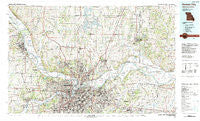
~ Kansas City MO topo map, 1:100000 scale, 30 X 60 Minute, Historical, 1983, updated 1983
Kansas City, Missouri, USGS topographic map dated 1983.
Includes geographic coordinates (latitude and longitude). This topographic map is suitable for hiking, camping, and exploring, or framing it as a wall map.
Printed on-demand using high resolution imagery, on heavy weight and acid free paper, or alternatively on a variety of synthetic materials.
Topos available on paper, Waterproof, Poly, or Tyvek. Usually shipping rolled, unless combined with other folded maps in one order.
- Product Number: USGS-5575458
- Free digital map download (high-resolution, GeoPDF): Kansas City, Missouri (file size: 35 MB)
- Map Size: please refer to the dimensions of the GeoPDF map above
- Weight (paper map): ca. 55 grams
- Map Type: POD USGS Topographic Map
- Map Series: HTMC
- Map Verison: Historical
- Cell ID: 67747
- Scan ID: 325373
- Imprint Year: 1983
- Woodland Tint: Yes
- Aerial Photo Year: 1980
- Edit Year: 1983
- Datum: NAD27
- Map Projection: Universal Transverse Mercator
- Map published by United States Geological Survey
- Map Language: English
- Scanner Resolution: 600 dpi
- Map Cell Name: Kansas City
- Grid size: 30 X 60 Minute
- Date on map: 1983
- Map Scale: 1:100000
- Geographical region: Missouri, United States
Neighboring Maps:
All neighboring USGS topo maps are available for sale online at a variety of scales.
Spatial coverage:
Topo map Kansas City, Missouri, covers the geographical area associated the following places:
- Dye - Claycomo - Glenbrook Mobile Home Community - Holt - Wadsworth - Barry - Beverly - Atherton - River Oaks Estates Mobile Home Park - Oakview - Victory Junction - Winner - Kansas Trailer Village - Crystal Lakes - Kickapoo - Holliday - Tracy - Houston Lake - Shawnee - American Eagle Mobile Home Estates - Woodruff - Hoge - Northmoor - Gashland - Coopers - Iatan - Wolcott - Muncie - Moscow - Winnwood Gardens - River View Mobile Country Club - Centropolis - Gladstone - Acme - Blue Mills - East Independence - Bethel - Merriam - Birmingham - Vibbard - Evanston - Westwood - Golf Hill - Oakwood - Camden - Sunflower Trailer Park - Buckner - Missouri City - Stony Point - Wildwoods Mobile Home Park - Sunflower - Basehor - Woodhill - Frisbie - Mission Woods - Lawson - Randolph - Sandals - Leeds - Maywood - Ferrelview - Kansas City - Edwardsville Mobile Home Village - Blue Springs - Trimble - Crescent Lake - Maple Garden - Pleasant Valley - Kansas City - Albany - Loma Vista - Oak Grove - South Liberty - Kearney - Pomeroy - Ectonville - Liberty Landing (historical) - Kerrville - Grinter Heights - Lake City - Bonner Springs - Bristol - Welborn - Minneville - Orrick - Grandview - Greenville - Air Line Junction - Buxton - Homestead - Hiler - Hampton - Lake Tapawingo - Chandler - Xavier - Selsa - Ripley - Cobbler - Cochrane - Waterloo
- Map Area ID: AREA39.539-95-94
- Northwest corner Lat/Long code: USGSNW39.5-95
- Northeast corner Lat/Long code: USGSNE39.5-94
- Southwest corner Lat/Long code: USGSSW39-95
- Southeast corner Lat/Long code: USGSSE39-94
- Northern map edge Latitude: 39.5
- Southern map edge Latitude: 39
- Western map edge Longitude: -95
- Eastern map edge Longitude: -94


