
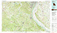
~ Festus MO topo map, 1:100000 scale, 30 X 60 Minute, Historical, 1985, updated 1987
Festus, Missouri, USGS topographic map dated 1985.
Includes geographic coordinates (latitude and longitude). This topographic map is suitable for hiking, camping, and exploring, or framing it as a wall map.
Printed on-demand using high resolution imagery, on heavy weight and acid free paper, or alternatively on a variety of synthetic materials.
Topos available on paper, Waterproof, Poly, or Tyvek. Usually shipping rolled, unless combined with other folded maps in one order.
- Product Number: USGS-5575444
- Free digital map download (high-resolution, GeoPDF): Festus, Missouri (file size: 35 MB)
- Map Size: please refer to the dimensions of the GeoPDF map above
- Weight (paper map): ca. 55 grams
- Map Type: POD USGS Topographic Map
- Map Series: HTMC
- Map Verison: Historical
- Cell ID: 67514
- Scan ID: 325366
- Imprint Year: 1987
- Woodland Tint: Yes
- Aerial Photo Year: 1982
- Edit Year: 1985
- Datum: NAD27
- Map Projection: Universal Transverse Mercator
- Map published by United States Geological Survey
- Map Language: English
- Scanner Resolution: 600 dpi
- Map Cell Name: Festus
- Grid size: 30 X 60 Minute
- Date on map: 1985
- Map Scale: 1:100000
- Geographical region: Missouri, United States
Neighboring Maps:
All neighboring USGS topo maps are available for sale online at a variety of scales.
Spatial coverage:
Topo map Festus, Missouri, covers the geographical area associated the following places:
- Madonnaville - White House - Happy Hollow - La Barque Creek - Koester - Beck - Piney Park - Weber Hill - Grubville - Gildehouse - Mapaville - Parkway - Hurricane - Riverside - Prairie du Rocher - Koch (historical) - Kidd - Phelps - Horine - Kellogg - Fletcher - Pohlman Mill - Waterloo - Rockford Beach - Wickes - Bushburg - Danby - Burksville Station - Flamm City - Tiff - Otto - Pevely - Dittmer - Brickeys - Harrisonville - Ten Brook - Imperial - Paderborn - Fountain Gap - Frumet - Flucom - Fertile - Ebo - Hematite - Olympian Village - Clement - Bellefontaine - Modoc - Bluffside - Spring Forest - Richwoods - Sunnyside - Meramec Terrace - Antonia - Mitchie - Mount Hope - Wartburg - Ware - Shibboleth - Papin - Millstadt - Hensley - Cannon Mines - Gray Summit - Byrnes Mill - Hemker - The Diamonds - Renault - Byers - Knorpp - Echo Lake Ranch - Valley View - Little Rock Landing - Granada Meadows - Bailey - Monroe City - Victoria - Mount Freedom - Scotsdale - Ames - Lakeside (historical) - Sulphur Springs - Jefferson Heights - Blackwell - Cottage Farm - High Ridge - Halifax - Regina - Moselle - Columbia - Cedar Hill Lakes - Oermann - Valmeyer - Pacific - Maupin - Belews Creek - Maddens Richwoods - Baryties - Paulina Hills - Hillsboro
- Map Area ID: AREA38.538-91-90
- Northwest corner Lat/Long code: USGSNW38.5-91
- Northeast corner Lat/Long code: USGSNE38.5-90
- Southwest corner Lat/Long code: USGSSW38-91
- Southeast corner Lat/Long code: USGSSE38-90
- Northern map edge Latitude: 38.5
- Southern map edge Latitude: 38
- Western map edge Longitude: -91
- Eastern map edge Longitude: -90


