
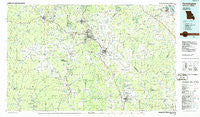
~ Farmington MO topo map, 1:100000 scale, 30 X 60 Minute, Historical, 1986, updated 1986
Farmington, Missouri, USGS topographic map dated 1986.
Includes geographic coordinates (latitude and longitude). This topographic map is suitable for hiking, camping, and exploring, or framing it as a wall map.
Printed on-demand using high resolution imagery, on heavy weight and acid free paper, or alternatively on a variety of synthetic materials.
Topos available on paper, Waterproof, Poly, or Tyvek. Usually shipping rolled, unless combined with other folded maps in one order.
- Product Number: USGS-5575440
- Free digital map download (high-resolution, GeoPDF): Farmington, Missouri (file size: 23 MB)
- Map Size: please refer to the dimensions of the GeoPDF map above
- Weight (paper map): ca. 55 grams
- Map Type: POD USGS Topographic Map
- Map Series: HTMC
- Map Verison: Historical
- Cell ID: 67508
- Scan ID: 325364
- Imprint Year: 1986
- Woodland Tint: Yes
- Aerial Photo Year: 1984
- Edit Year: 1986
- Datum: NAD27
- Map Projection: Universal Transverse Mercator
- Planimetric: Yes
- Map published by United States Geological Survey
- Map Language: English
- Scanner Resolution: 600 dpi
- Map Cell Name: Farmington
- Grid size: 30 X 60 Minute
- Date on map: 1986
- Map Scale: 1:100000
- Geographical region: Missouri, United States
Neighboring Maps:
All neighboring USGS topo maps are available for sale online at a variety of scales.
Spatial coverage:
Topo map Farmington, Missouri, covers the geographical area associated the following places:
- Pilot Knob - Peoria - Middlebrook - Mill - Sunlight - Pin Hook - Jonca - Tin Mountain - Frogtown - Rivermines - Braddy Ford (historical) - Frankclay - Fairview Acres - Sprott - Hurryville - Lawrenceton - Cornwall - Copper Mine - Pickel - Bismarck - Ironton - Enough (historical) - North Patton - Silver Springs - New Offenburg - Latty - Womack - Leadwood - The Lead Belt - Catherine Place - Settletown - Huntington - Libertyville - Millcreek - Hamilton Town - Elvins - Lake Forest Estates - Hahns Mill - Davis - English Town - Summit - Cobalt Village - Roselle - Chestnut Ridge - Saint Jude Acres - Hopewell - Cadet - Daytown - Farmington - White (historical) - Wortham - Holiday Shores - Esther - Loughboro - Fountain Farm - Hazel Run - Rocky Ridge Ranch - Belgrade - Hogan - Shepard (historical) - Coffman - Irondale - Lance - Springtown - West Elvins - Corners - Zell - Weingarten - Marlo - New Bourbon - Castor Station - Patton - Terre du Lac - Graniteville - Saint Francois - Derby - Maxwells Mill - Snow Hollow Lake - Federal - Killarney Shores - Flat River - Pinkley (historical) - Fredericktown - Mosher - Ogborn - Monterey - Millers - Hoffman Junction - Russellville - Lopez - Ezra (historical) - Doe Run - East Bonne Terre - Iron Mountain Lake - Arcadia - Higdon - Park Hills - Rock Springs - Junction City - Cross Roads
- Map Area ID: AREA3837.5-91-90
- Northwest corner Lat/Long code: USGSNW38-91
- Northeast corner Lat/Long code: USGSNE38-90
- Southwest corner Lat/Long code: USGSSW37.5-91
- Southeast corner Lat/Long code: USGSSE37.5-90
- Northern map edge Latitude: 38
- Southern map edge Latitude: 37.5
- Western map edge Longitude: -91
- Eastern map edge Longitude: -90


