
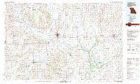
~ Chillicothe MO topo map, 1:100000 scale, 30 X 60 Minute, Historical, 1981, updated 1981
Chillicothe, Missouri, USGS topographic map dated 1981.
Includes geographic coordinates (latitude and longitude). This topographic map is suitable for hiking, camping, and exploring, or framing it as a wall map.
Printed on-demand using high resolution imagery, on heavy weight and acid free paper, or alternatively on a variety of synthetic materials.
Topos available on paper, Waterproof, Poly, or Tyvek. Usually shipping rolled, unless combined with other folded maps in one order.
- Product Number: USGS-5575438
- Free digital map download (high-resolution, GeoPDF): Chillicothe, Missouri (file size: 26 MB)
- Map Size: please refer to the dimensions of the GeoPDF map above
- Weight (paper map): ca. 55 grams
- Map Type: POD USGS Topographic Map
- Map Series: HTMC
- Map Verison: Historical
- Cell ID: 67290
- Scan ID: 325363
- Imprint Year: 1981
- Woodland Tint: Yes
- Aerial Photo Year: 1978
- Edit Year: 1981
- Datum: NAD27
- Map Projection: Universal Transverse Mercator
- Map published by United States Geological Survey
- Map Language: English
- Scanner Resolution: 600 dpi
- Map Cell Name: Chillicothe
- Grid size: 30 X 60 Minute
- Date on map: 1981
- Map Scale: 1:100000
- Geographical region: Missouri, United States
Neighboring Maps:
All neighboring USGS topo maps are available for sale online at a variety of scales.
Spatial coverage:
Topo map Chillicothe, Missouri, covers the geographical area associated the following places:
- Brookfield - Harmony (historical) - Purdin - Blake - Cleary - Shafter - Indian Grove - Little Compton - Snyder - Fisher (historical) - Norville - Avalon - Asper - Cream Ridge - Sturges - Hale - Hickory Creek - Rothville - Ludlow - Nettleton - Dawn - Tina - Shelby - Wabash Crossing - Linneus - Chula - Sampsel - Grace - Shoal - Bonanza - Farmersville - Proctorville - Chillicothe - Cowgill - Alpha - Eversonville - Lock Springs - Mooresville - Gallatin - Springhill - Leverton - Jamesport - Hecla - Laclede - Catawba - Mendon - Bridge Creek - Bedford - Latoh (historical) - Braymer - Fountain Grove - Whitham - Breckenridge - Genova - Bear Branch - Meadville - Carlow - Coloma - Cavendish - Easterville - Sumner - Utica - Black Oak - Newcomer - Lowell - Corner Campbell School - Silverleaf - Blue Mound - Tinney Grove - Forker - Magill - New York - Cunningham - Niantic - Leopolis (historical) - Wheeling - Hamilton - Quote - Gould Farm - Grantsville - Plymouth - Newhall
- Map Area ID: AREA4039.5-94-93
- Northwest corner Lat/Long code: USGSNW40-94
- Northeast corner Lat/Long code: USGSNE40-93
- Southwest corner Lat/Long code: USGSSW39.5-94
- Southeast corner Lat/Long code: USGSSE39.5-93
- Northern map edge Latitude: 40
- Southern map edge Latitude: 39.5
- Western map edge Longitude: -94
- Eastern map edge Longitude: -93


