
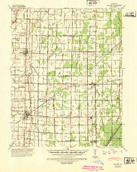
~ Malden MO topo map, 1:62500 scale, 15 X 15 Minute, Historical, 1940, updated 1942
Malden, Missouri, USGS topographic map dated 1940.
Includes geographic coordinates (latitude and longitude). This topographic map is suitable for hiking, camping, and exploring, or framing it as a wall map.
Printed on-demand using high resolution imagery, on heavy weight and acid free paper, or alternatively on a variety of synthetic materials.
Topos available on paper, Waterproof, Poly, or Tyvek. Usually shipping rolled, unless combined with other folded maps in one order.
- Product Number: USGS-5574880
- Free digital map download (high-resolution, GeoPDF): Malden, Missouri (file size: 7 MB)
- Map Size: please refer to the dimensions of the GeoPDF map above
- Weight (paper map): ca. 55 grams
- Map Type: POD USGS Topographic Map
- Map Series: HTMC
- Map Verison: Historical
- Cell ID: 57064
- Scan ID: 325049
- Imprint Year: 1942
- Woodland Tint: Yes
- Edit Year: 1940
- Datum: NAD
- Map Projection: Polyconic
- Map published by United States Army Corps of Engineers
- Map published by United States Department of War
- Map Language: English
- Scanner Resolution: 600 dpi
- Map Cell Name: Malden
- Grid size: 15 X 15 Minute
- Date on map: 1940
- Map Scale: 1:62500
- Geographical region: Missouri, United States
Neighboring Maps:
All neighboring USGS topo maps are available for sale online at a variety of scales.
Spatial coverage:
Topo map Malden, Missouri, covers the geographical area associated the following places:
- Turner - Tallapoosa - Baxter - Providence - Townley - Miller (historical) - Melby - Crumpecker (historical) - Wila (historical) - Marco - Risco - Lorwood - Maulsby - Como - Nordlow (historical) - Hills Store - Spoonerville - Bernie - Broadwater - LaValle - Parma - Forest Spur - Malden - Bunker Hill
- Map Area ID: AREA36.7536.5-90-89.75
- Northwest corner Lat/Long code: USGSNW36.75-90
- Northeast corner Lat/Long code: USGSNE36.75-89.75
- Southwest corner Lat/Long code: USGSSW36.5-90
- Southeast corner Lat/Long code: USGSSE36.5-89.75
- Northern map edge Latitude: 36.75
- Southern map edge Latitude: 36.5
- Western map edge Longitude: -90
- Eastern map edge Longitude: -89.75


