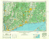
~ Hartford CT topo map, 1:250000 scale, 1 X 2 Degree, Historical, 1947, updated 1955
Hartford, Connecticut, USGS topographic map dated 1947.
Includes geographic coordinates (latitude and longitude). This topographic map is suitable for hiking, camping, and exploring, or framing it as a wall map.
Printed on-demand using high resolution imagery, on heavy weight and acid free paper, or alternatively on a variety of synthetic materials.
Topos available on paper, Waterproof, Poly, or Tyvek. Usually shipping rolled, unless combined with other folded maps in one order.
- Product Number: USGS-5566638
- Free digital map download (high-resolution, GeoPDF): Hartford, Connecticut (file size: 29 MB)
- Map Size: please refer to the dimensions of the GeoPDF map above
- Weight (paper map): ca. 55 grams
- Map Type: POD USGS Topographic Map
- Map Series: HTMC
- Map Verison: Historical
- Cell ID: 72228
- Scan ID: 331218
- Imprint Year: 1955
- Woodland Tint: Yes
- Aerial Photo Year: 1946
- Datum: NAD27
- Map Projection: Transverse Mercator
- Map published by United States Army Corps of Engineers
- Map published by United States Army
- Map published by United States Department of War
- Map Language: English
- Scanner Resolution: 600 dpi
- Map Cell Name: Hartford
- Grid size: 1 X 2 Degree
- Date on map: 1947
- Map Scale: 1:250000
- Geographical region: Connecticut, United States
Neighboring Maps:
All neighboring USGS topo maps are available for sale online at a variety of scales.
Spatial coverage:
Topo map Hartford, Connecticut, covers the geographical area associated the following places:
- Fitchville - Saybrook Manor - Riverdale - Couch Corners - Cedar Lake - Strawberry Acres Mobile Home Park - Hockanum - Manor Hill Mobile Home Park - Colonial Heights - Stafford Springs - Hickory Haven - Dover Furnace - Tylerville - Huntersville (historical) - Kensington - Twin Lakes Village - East Berlin - Avon Park South - Bakersville - Wellsville - Scotland - City Point - Mill Plain - Finktown - Glenclyffe - Wormwood Hill - Reydon Shores - Warrenville - Oregon - Beekman - East Village - Peconic - Pondside - Hayden - South Windham - Huntsville - Case Corner - Charlotte Grove Mobile Court - West Nyack - Kelly Corner - Village Hill - Candlewood Shores - Quinnipiac - Shenorock - Tunxis Hill - Ridgefield - Redding - Terramuggus - West Morris - East Cutchogue - Dennytown - Kent Cliffs - Littlerest - Steinbeck Corners - Bay Point - Quarryville - Norwalk - Southport - North White Plains - Roxbury - New Guinea (historical) - High Plains - Winsted - Beixedon Estates - Sunnyside - Trails Corner - Saugatuck - Valley Mobile Home Park - Warehouse Point - Ludingtonville - Meadowgate - Corner of the Pines - Clintonville - Candlewood Lake Club - Pleasant Plains - Shady Lane Mobile Home Park - Milestone Corner - Tappan - South Canaan - Millwood - Williams Crossing - Port Ewen - Jewitt Corner - Fitch Corner - Romford - Gaylordsville - Cottage Grove - Clinton Beach - Davidsons Corner - Titicus - Southford - Colchester - Redding Ridge - Purdys - Arlington - Mansfield Center - East Park Mobile Home Park - Lake Purdy - Newtown - Northfield
- Map Area ID: AREA4241-74-72
- Northwest corner Lat/Long code: USGSNW42-74
- Northeast corner Lat/Long code: USGSNE42-72
- Southwest corner Lat/Long code: USGSSW41-74
- Southeast corner Lat/Long code: USGSSE41-72
- Northern map edge Latitude: 42
- Southern map edge Latitude: 41
- Western map edge Longitude: -74
- Eastern map edge Longitude: -72