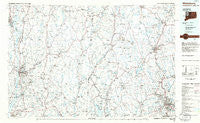
~ Waterbury CT topo map, 1:100000 scale, 30 X 60 Minute, Historical, 1985, updated 1986
Waterbury, Connecticut, USGS topographic map dated 1985.
Includes geographic coordinates (latitude and longitude). This topographic map is suitable for hiking, camping, and exploring, or framing it as a wall map.
Printed on-demand using high resolution imagery, on heavy weight and acid free paper, or alternatively on a variety of synthetic materials.
Topos available on paper, Waterproof, Poly, or Tyvek. Usually shipping rolled, unless combined with other folded maps in one order.
- Product Number: USGS-5566624
- Free digital map download (high-resolution, GeoPDF): Waterbury, Connecticut (file size: 22 MB)
- Map Size: please refer to the dimensions of the GeoPDF map above
- Weight (paper map): ca. 55 grams
- Map Type: POD USGS Topographic Map
- Map Series: HTMC
- Map Verison: Historical
- Cell ID: 68550
- Scan ID: 331230
- Imprint Year: 1986
- Aerial Photo Year: 1983
- Edit Year: 1985
- Datum: NAD27
- Map Projection: Universal Transverse Mercator
- Planimetric: Yes
- Map published by United States Geological Survey
- Map Language: English
- Scanner Resolution: 600 dpi
- Map Cell Name: Waterbury
- Grid size: 30 X 60 Minute
- Date on map: 1985
- Map Scale: 1:100000
- Geographical region: Connecticut, United States
Neighboring Maps:
All neighboring USGS topo maps are available for sale online at a variety of scales.
Spatial coverage:
Topo map Waterbury, Connecticut, covers the geographical area associated the following places:
- Sheafe Manor Mobile Home Park - Middlebury - Manchester Bridge - Greystone - Stissing - Amenia - Waterbury - Robertsville - Webatuck - Lakewood - Billings - Camelot Village Mobile Home Park - Beekman - Patterson - New Hamburg - Bains Corner - Sandy Beach - Red Hook Mobile Home Park - Lafayetteville - Stormville - Roxbury Station - Market - Hughsonville - Joyceland (historical) - Terryville - Fishkill - West Cornwall - Millbrook - Barrytown - Hurd Corners - Haviland - Hopeville - Shady Brook - Red Oaks Mill - Brockway - Hudson Heights - Lakeville - Coleman Station - Bethlehem - West Side Hill - Leedsville - Rondout - Weys Corners - Grantville - Green Haven - Gulls Hollow - North Clove - South Millbrook - Powell Mobile Home Park - Northeast - Charlotte Grove Mobile Court - Titusville - Sylvan Lake - Valley Forge Mobile Home Park - Mabbettsville - Wassaic - Watertown - Platts Mills - Roxbury - Campville - Bakersville - Rochdale - Lakeside - Northfield - Tyler Lake Heights - Brinckerhoff - Fishkill Plains - Candlewood Springs - Walnut Lane Mobile Home Park - Scenic View Trailer Park - West Woods - Gaylordsville - Pomeraug - Esopus - Lagrangeville - Rhinebeck Manor Mobile Home Park - North Goshen - Manor Hill Mobile Home Park - Castle Point - Atchison Cove - Freedom Plains - Hyde Park - Winsted - Snows Mobile Home Park - Chimney Point - Hammertown - Burrville - East Morris - Wappingers Falls - Clove - Fairmount - Connelly Village Mobile Home Park - Barnegat - Mooreville - Swartoutville - Morris - West Goshen - Roberts Mobile Home Park - Rombout Ridge - Westview Heights
- Map Area ID: AREA4241.5-74-73
- Northwest corner Lat/Long code: USGSNW42-74
- Northeast corner Lat/Long code: USGSNE42-73
- Southwest corner Lat/Long code: USGSSW41.5-74
- Southeast corner Lat/Long code: USGSSE41.5-73
- Northern map edge Latitude: 42
- Southern map edge Latitude: 41.5
- Western map edge Longitude: -74
- Eastern map edge Longitude: -73