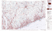
~ Bridgeport CT topo map, 1:100000 scale, 30 X 60 Minute, Historical, 1986, updated 1986
Bridgeport, Connecticut, USGS topographic map dated 1986.
Includes geographic coordinates (latitude and longitude). This topographic map is suitable for hiking, camping, and exploring, or framing it as a wall map.
Printed on-demand using high resolution imagery, on heavy weight and acid free paper, or alternatively on a variety of synthetic materials.
Topos available on paper, Waterproof, Poly, or Tyvek. Usually shipping rolled, unless combined with other folded maps in one order.
- Product Number: USGS-5566610
- Free digital map download (high-resolution, GeoPDF): Bridgeport, Connecticut (file size: 32 MB)
- Map Size: please refer to the dimensions of the GeoPDF map above
- Weight (paper map): ca. 55 grams
- Map Type: POD USGS Topographic Map
- Map Series: HTMC
- Map Verison: Historical
- Cell ID: 67182
- Scan ID: 331206
- Imprint Year: 1986
- Aerial Photo Year: 1983
- Edit Year: 1986
- Datum: NAD27
- Map Projection: Universal Transverse Mercator
- Planimetric: Yes
- Map published by United States Geological Survey
- Map Language: English
- Scanner Resolution: 600 dpi
- Map Cell Name: Bridgeport
- Grid size: 30 X 60 Minute
- Date on map: 1986
- Map Scale: 1:100000
- Geographical region: Connecticut, United States
Neighboring Maps:
All neighboring USGS topo maps are available for sale online at a variety of scales.
Spatial coverage:
Topo map Bridgeport, Connecticut, covers the geographical area associated the following places:
- Five Points - Putney - Forest Park - Paynes Corners - Drewville Heights - Byram - New City - Naugatuck Junction - Plattsville - Baldwin Place - Lake Peekskill - Aqua Vista - Millwood - Newfield - Oronoque Hills South - Finktown - Battle Hill - East White Plains - Cedar Heights - Sanfordtown - Brewster Heights - Mill Plain - Croton Falls - Cedar Land - Lake Carmel - Tompkins Corners - Eastview - Aspetuck - Ardsley - Putnam Lake - Silver Beach - Cedar Beach - Murray - Horseshoe Hill - Botsford - Nelson Corners - East Derby - Southbury - Southford - North Salem - Pleasantville - Valley Mobile Home Park - Lake Lucille - North Mianus - West Redding - Glenville - Northvale - North Stamford - Hockanum Park (historical) - Bayview - Monroe - Harmon - Wildmans Landing - Hopewell - Grover Hill - Darien - Redding - Crompond - Rivercliff - Hollywyle Park - White Plains - Snug Harbor - Belltown - Allen Corners - Cranbury - Brookside Senior Citizen Cooperative - Manitou - Hunting Ridge - West Nyack - Barnum Corners - Oronoque Hills North - Haverstraw - Cedarhurst - Lincolndale - Riversville - Wilton - Little Danbury (historical) - Upper Nyack - West Haverstraw - Mohegan Lake - Southport - Rock Ridge - Old Tappan - High Ridge - Gallows Hill - Gilbert Corners - Germonds - Robert Hutt Congregate Housing - Highland Falls - Tilly Foster - Deforest Corners - Orangeburg - Crotonville - Mill Plain - Palmers Hill - Roe Park - Kitchawan - Westport - Norwalk - Sears Corners
- Map Area ID: AREA41.541-74-73
- Northwest corner Lat/Long code: USGSNW41.5-74
- Northeast corner Lat/Long code: USGSNE41.5-73
- Southwest corner Lat/Long code: USGSSW41-74
- Southeast corner Lat/Long code: USGSSE41-73
- Northern map edge Latitude: 41.5
- Southern map edge Latitude: 41
- Western map edge Longitude: -74
- Eastern map edge Longitude: -73