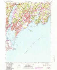
~ Milford CT topo map, 1:24000 scale, 7.5 X 7.5 Minute, Historical, 1984, updated 1984
Milford, Connecticut, USGS topographic map dated 1984.
Includes geographic coordinates (latitude and longitude). This topographic map is suitable for hiking, camping, and exploring, or framing it as a wall map.
Printed on-demand using high resolution imagery, on heavy weight and acid free paper, or alternatively on a variety of synthetic materials.
Topos available on paper, Waterproof, Poly, or Tyvek. Usually shipping rolled, unless combined with other folded maps in one order.
- Product Number: USGS-5565586
- Free digital map download (high-resolution, GeoPDF): Milford, Connecticut (file size: 15 MB)
- Map Size: please refer to the dimensions of the GeoPDF map above
- Weight (paper map): ca. 55 grams
- Map Type: POD USGS Topographic Map
- Map Series: HTMC
- Map Verison: Historical
- Cell ID: 29258
- Scan ID: 330664
- Imprint Year: 1984
- Woodland Tint: Yes
- Photo Revision Year: 1984
- Aerial Photo Year: 1982
- Edit Year: 1984
- Field Check Year: 1951
- Datum: NAD27
- Map Projection: Polyconic
- Map Language: English
- Scanner Resolution: 600 dpi
- Map Cell Name: Milford
- Grid size: 7.5 X 7.5 Minute
- Date on map: 1984
- Map Scale: 1:24000
- Geographical region: Connecticut, United States
Neighboring Maps:
All neighboring USGS topo maps are available for sale online at a variety of scales.
Spatial coverage:
Topo map Milford, Connecticut, covers the geographical area associated the following places:
- Walnut Beach - Naugatuck Gardens - Oronoque Hills South - Devon - Baldwins Crossing - Putney - City of Milford (balance) - Rivercliff - Point Beach - Myrtle Beach - Milford Lawns - Johnsons Corner - Cedar Beach - Wildermere Beach - Silver Beach - Pecks Mill - Forest Heights - Naugatuck Junction - Laurel Beach - Lordship - Oronoque - Morningside - Bayview - Fort Trumbull - Milford
- Map Area ID: AREA41.2541.125-73.125-73
- Northwest corner Lat/Long code: USGSNW41.25-73.125
- Northeast corner Lat/Long code: USGSNE41.25-73
- Southwest corner Lat/Long code: USGSSW41.125-73.125
- Southeast corner Lat/Long code: USGSSE41.125-73
- Northern map edge Latitude: 41.25
- Southern map edge Latitude: 41.125
- Western map edge Longitude: -73.125
- Eastern map edge Longitude: -73