
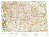
~ Omaha NE topo map, 1:250000 scale, 1 X 2 Degree, Historical, 1958, updated 1958
Omaha, Nebraska, USGS topographic map dated 1958.
Includes geographic coordinates (latitude and longitude). This topographic map is suitable for hiking, camping, and exploring, or framing it as a wall map.
Printed on-demand using high resolution imagery, on heavy weight and acid free paper, or alternatively on a variety of synthetic materials.
Topos available on paper, Waterproof, Poly, or Tyvek. Usually shipping rolled, unless combined with other folded maps in one order.
- Product Number: USGS-5564098
- Free digital map download (high-resolution, GeoPDF): Omaha, Nebraska (file size: 24 MB)
- Map Size: please refer to the dimensions of the GeoPDF map above
- Weight (paper map): ca. 55 grams
- Map Type: POD USGS Topographic Map
- Map Series: HTMC
- Map Verison: Historical
- Cell ID: 68948
- Scan ID: 317944
- Imprint Year: 1958
- Woodland Tint: Yes
- Aerial Photo Year: 1950
- Field Check Year: 1954
- Datum: Unstated
- Map Projection: Transverse Mercator
- Map published by United States Army Corps of Engineers
- Map published by United States Army
- Map Language: English
- Scanner Resolution: 600 dpi
- Map Cell Name: Omaha
- Grid size: 1 X 2 Degree
- Date on map: 1958
- Map Scale: 1:250000
- Geographical region: Nebraska, United States
Neighboring Maps:
All neighboring USGS topo maps are available for sale online at a variety of scales.
Spatial coverage:
Topo map Omaha, Nebraska, covers the geographical area associated the following places:
- Massena - Chautauqua - Paradise Park - Shelby - Bar-Jac Mobile Estates - Golden Spike Mobile Home Park - Crescent - Oakland - Peter - Washington Mobile Home Terrace - Angus - Poplar - Balfour - Baird - Arion - Echo - Calhoun - Avery - Ross - Union Burg (historical) - Williamson - Silver City - Manilla - Loveland - Oreapolis - Tenville - Sciola - Dale - Carl - Menlo - Nanito - Berkley - Capehart - Barney - Macksburg - Nishna - Grove City (historical) - Sands Trailer Park - Poplar - Griswold - Redfield - Manteno - Pisgah - Lorimor - Persia - Fiscus - Prescott - Howe - Iola (historical) - McPherson - Bell - Lewis - Dewey - HiVue Mobile Home Park - La Platte - Elk Horn - York Center - Oakfield - Black Corners - Nevinville - Minden - Willett - Rosserdale - Glenwood - Fanslers - Queen City (historical) - Gilliatt - Earling - Avoca - Orson - Wallin - Mineola - Prussia - Mount Etna - Dedham - Webster - Dickieville - Hebron - Morrisburgh (historical) - Kennedy - Henderson - Wooded Lake Mobile Home Park - Orient - Hancock - Corley - East Creston - Minburn - Gardiner - Elliott - Regency of Iowa Mobile Home Park - Ascot - Creston - Coon Rapids - Talmage - Wiota - Morton Mills - Portsmouth - Panama - Malvern - Hawthorne
- Map Area ID: AREA4241-96-94
- Northwest corner Lat/Long code: USGSNW42-96
- Northeast corner Lat/Long code: USGSNE42-94
- Southwest corner Lat/Long code: USGSSW41-96
- Southeast corner Lat/Long code: USGSSE41-94
- Northern map edge Latitude: 42
- Southern map edge Latitude: 41
- Western map edge Longitude: -96
- Eastern map edge Longitude: -94


