
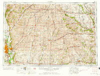
~ Omaha NE topo map, 1:250000 scale, 1 X 2 Degree, Historical, 1958, updated 1958
Omaha, Nebraska, USGS topographic map dated 1958.
Includes geographic coordinates (latitude and longitude). This topographic map is suitable for hiking, camping, and exploring, or framing it as a wall map.
Printed on-demand using high resolution imagery, on heavy weight and acid free paper, or alternatively on a variety of synthetic materials.
Topos available on paper, Waterproof, Poly, or Tyvek. Usually shipping rolled, unless combined with other folded maps in one order.
- Product Number: USGS-5564092
- Free digital map download (high-resolution, GeoPDF): Omaha, Nebraska (file size: 25 MB)
- Map Size: please refer to the dimensions of the GeoPDF map above
- Weight (paper map): ca. 55 grams
- Map Type: POD USGS Topographic Map
- Map Series: HTMC
- Map Verison: Historical
- Cell ID: 68948
- Scan ID: 317941
- Imprint Year: 1958
- Woodland Tint: Yes
- Visual Version Number: 1
- Aerial Photo Year: 1950
- Field Check Year: 1954
- Datum: Unstated
- Map Projection: Transverse Mercator
- Map published by United States Army Corps of Engineers
- Map published by United States Army
- Map Language: English
- Scanner Resolution: 600 dpi
- Map Cell Name: Omaha
- Grid size: 1 X 2 Degree
- Date on map: 1958
- Map Scale: 1:250000
- Geographical region: Nebraska, United States
Neighboring Maps:
All neighboring USGS topo maps are available for sale online at a variety of scales.
Spatial coverage:
Topo map Omaha, Nebraska, covers the geographical area associated the following places:
- Frankfort (historical) - Lyman - Creston - Accent Mobile Home Parks - Bell - Dow City - Beebeetown - Wichita - McPherson - Gilliatt - Emerson - Home Park - Chautauqua - Nashville - Ascot - Euclid - Cromwell - Dale - Indiantown (historical) - Magill - Treynor - Clara - Mills - Hancock - Strand - Gardner - Prescott - Moorhead - North Branch - Hill City Mobile Home Park - Menlo - California Junction - Hillsdale - Washington Mobile Home Terrace - Webster - Bayard - Sciola - Overland Mobile Home Park - Barney - Brayton - Carl - Plattsmouth - Honey Creek - HiVue Mobile Home Park - Buffalo (historical) - Exira - Macksburg - Country Estates Mobile Home Park - Earling - East Creston - Gilmore - Lincoln Center - Dunlap - Bellevue - Corley - Buck Grove - Oakfield - Nevinville - Wiscotta - Greenfield - Orient - Aspinwall - Capehart - Zion - Griswold - Omaha - Bar-Jac Mobile Estates - Defiance - Adair - Lorah - River Vista Trailer Park - Spaulding - Garden Valley Courts - Atlantic - Pisgah - Golden Spike Mobile Home Park - Crisp - Adel - Shelby - Arion - Pacific Junction - Herndon - Cumberland - Oreapolis - Viola Center - Mount Etna - Templeton - Pacific City - Henderson - Glenwood - Hawthorne - Grable - Nishna - Mineola - Kimballton - Black Corners - Newtown (historical) - Bridgewater - La Platte - Linden
- Map Area ID: AREA4241-96-94
- Northwest corner Lat/Long code: USGSNW42-96
- Northeast corner Lat/Long code: USGSNE42-94
- Southwest corner Lat/Long code: USGSSW41-96
- Southeast corner Lat/Long code: USGSSE41-94
- Northern map edge Latitude: 42
- Southern map edge Latitude: 41
- Western map edge Longitude: -96
- Eastern map edge Longitude: -94


