
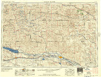
~ North Platte NE topo map, 1:250000 scale, 1 X 2 Degree, Historical, 1957, updated 1957
North Platte, Nebraska, USGS topographic map dated 1957.
Includes geographic coordinates (latitude and longitude). This topographic map is suitable for hiking, camping, and exploring, or framing it as a wall map.
Printed on-demand using high resolution imagery, on heavy weight and acid free paper, or alternatively on a variety of synthetic materials.
Topos available on paper, Waterproof, Poly, or Tyvek. Usually shipping rolled, unless combined with other folded maps in one order.
- Product Number: USGS-5564082
- Free digital map download (high-resolution, GeoPDF): North Platte, Nebraska (file size: 23 MB)
- Map Size: please refer to the dimensions of the GeoPDF map above
- Weight (paper map): ca. 55 grams
- Map Type: POD USGS Topographic Map
- Map Series: HTMC
- Map Verison: Historical
- Cell ID: 68937
- Scan ID: 317936
- Imprint Year: 1957
- Woodland Tint: Yes
- Field Check Year: 1954
- Datum: Unstated
- Map Projection: Transverse Mercator
- Map published by United States Army Corps of Engineers
- Map published by United States Army
- Map Language: English
- Scanner Resolution: 600 dpi
- Map Cell Name: North Platte
- Grid size: 1 X 2 Degree
- Date on map: 1957
- Map Scale: 1:250000
- Geographical region: Nebraska, United States
Neighboring Maps:
All neighboring USGS topo maps are available for sale online at a variety of scales.
Spatial coverage:
Topo map North Platte, Nebraska, covers the geographical area associated the following places:
- Bignell - Nevens - Mobile Manor - Pleasant Hill - Bucktail - O'Fallons - Rounds Place - L and L Mobile Home Park - Broganville - Beck - Lena - Roscoe - Brady - Lyons Place - Key Estates - Halsey - Velma - Sutherland - Keith - Lemoyne - Gandy - Ogallala - Etna - Dunning - Martin - Hoagland - Hershey - Belmar - Logan - Flats - Tri States Trailer Court - Maxwell - Natick - Stapleton - Arnold - Brule - Paxton - McKeag - Birdwood - Sioux View Park - Beals Trailer Court - Keystone - Green Acres Trailer Court - Finchville - Megeath - Coker - Arthur - Sarben - Linscott - Ringgold - Lemoyne Mobile Home Park - North Platte - Norway - Calora - Village Square - Myrtle (historical) - Tryon - Thedford
- Map Area ID: AREA4241-102-100
- Northwest corner Lat/Long code: USGSNW42-102
- Northeast corner Lat/Long code: USGSNE42-100
- Southwest corner Lat/Long code: USGSSW41-102
- Southeast corner Lat/Long code: USGSSE41-100
- Northern map edge Latitude: 42
- Southern map edge Latitude: 41
- Western map edge Longitude: -102
- Eastern map edge Longitude: -100


